
Bečov nad Teplou
Bečov nad Teplou | |
|---|---|
Town | |
 Bečov Castle | |
 Flag  Coat of arms | |
 Bečov nad Teplou Location in the Czech Republic | |
| Coordinates: 50°5′0″N 12°50′18″E / 50.08333°N 12.83833°E | |
| Country | |
| Region | Karlovy Vary |
| District | Karlovy Vary |
| First mentioned | 14th century |
| Government | |
| • Mayor | Miroslav Nepraš |
| Area | |
| • Total | 19.81 km2 (7.65 sq mi) |
| Elevation | 532 m (1,745 ft) |
| Population (2020-01-01[1]) | |
| • Total | 942 |
| • Density | 48/km2 (120/sq mi) |
| Time zone | UTC+1 (CET) |
| • Summer (DST) | UTC+2 (CEST) |
| Postal code | 364 64 |
| Website | www |
Bečov nad Teplou (German: Petschau) is a town in the Karlovy Vary Region of the Czech Republic. It has a population of about 900.
Gallery
-
 Gate house of Bečov Castle
 -
 Facade of the Bečov Town Hall with the coat of arms
 -
 Another view of the Castle
 -
 The old Hotel Central
 -
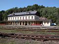 Bečov nad Teplou Railway Station


See also
References
- ^ "Population of Municipalities – 1 January 2020". Czech Statistical Office. 2020-04-30.
External links
 Media related to Bečov nad Teplou at Wikimedia Commons
- Municipal website
You can help expand this article with text translated from the corresponding article in Czech. (June 2018) Click [show] for important translation instructions.
|
| International | |
|---|---|
| National | |
This Karlovy Vary Region location article is a stub. You can help Wikipedia by expanding it. |