
Walheim, Haut-Rhin
Walheim
Wàhle | |
|---|---|
 The town hall in Walheim | |
.svg) Coat of arms | |
Location of Walheim  | |
 Walheim  Walheim | |
| Coordinates: 47°38′34″N 7°16′01″E / 47.6428°N 7.2669°E | |
| Country | France |
| Region | Grand Est |
| Department | Haut-Rhin |
| Arrondissement | Altkirch |
| Canton | Altkirch |
| Intercommunality | Sundgau |
| Government | |
| • Mayor (2014-2020) | Chrysanthe Camilo |
| Area 1 | 4.83 km2 (1.86 sq mi) |
| Population (2021)[1] | 885 |
| • Density | 180/km2 (470/sq mi) |
| Time zone | UTC+01:00 (CET) |
| • Summer (DST) | UTC+02:00 (CEST) |
| INSEE/Postal code | 68356 /68130 |
| Elevation | 267–393 m (876–1,289 ft) (avg. 285 m or 935 ft) |
| 1 French Land Register data, which excludes lakes, ponds, glaciers > 1 km2 (0.386 sq mi or 247 acres) and river estuaries. | |
Walheim (Alemannic German: Wàhle) is a communes in the Haut-Rhin department in Alsace in north-eastern France.
-
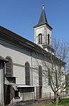 Saint Martin Church
 -
 Saint Martin Church


Population
| Year | Pop. | ±% |
|---|---|---|
| 2006 | 878 | — |
| 2007 | 886 | +0.9% |
| 2008 | 894 | +0.9% |
| 2009 | 911 | +1.9% |
| 2010 | 927 | +1.8% |
| 2011 | 944 | +1.8% |
| 2012 | 951 | +0.7% |
| 2013 | 956 | +0.5% |
| 2014 | 938 | −1.9% |
| 2015 | 920 | −1.9% |
| 2016 | 902 | −2.0% |
See also
References
- ^ "Populations légales 2021" (in French). The National Institute of Statistics and Economic Studies. 28 December 2023.
Wikimedia Commons has media related to Walheim (Haut-Rhin).
| National | |
|---|---|
| Other | |
This Haut-Rhin geographical article is a stub. You can help Wikipedia by expanding it. |