
Wusterhausen
Wusterhausen | |
|---|---|
 Church in Nackel | |
.png) Coat of arms | |
Location of Wusterhausen within Ostprignitz-Ruppin district  | |
 Wusterhausen  Wusterhausen | |
| Coordinates: 52°52′59″N 12°28′00″E / 52.88306°N 12.46667°E | |
| Country | Germany |
| State | Brandenburg |
| District | Ostprignitz-Ruppin |
| Government | |
| • Mayor | Philipp Schulz (Ind.) |
| Area | |
| • Total | 195.42 km2 (75.45 sq mi) |
| Elevation | 33 m (108 ft) |
| Population (2022-12-31)[1] | |
| • Total | 5,854 |
| • Density | 30/km2 (78/sq mi) |
| Time zone | UTC+01:00 (CET) |
| • Summer (DST) | UTC+02:00 (CEST) |
| Postal codes | 16868 |
| Dialling codes | 033979 |
| Vehicle registration | OPR |
| Website | www.wusterhausen.de |
Wusterhausen (official name Wusterhausen/Dosse) is a municipality in the Ostprignitz-Ruppin district, in northwestern Brandenburg, Germany. It is situated on the river Dosse, 7 km southeast of Kyritz, and 75 km northwest of Berlin.
Demography
-
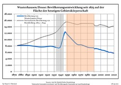 Development of population since 1875 within the current Boundaries (Blue Line: Population; Dotted Line: Comparison to Population development in Brandenburg state; Grey Background: Time of Nazi Germany; Red Background: Time of communist East Germany)
 -
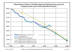 Recent Population Development and Projections (Population Development before Census 2011 (blue line); Recent Population Development according to the Census in Germany in 2011 (blue bordered line); Official projections for 2005-2030 (yellow line); for 2014-2030 (red line); for 2017-2030 (scarlet line)


|
|
|
People
- Hermann Wagener (1815-1889), journalist and politician
References

- ^ "Bevölkerungsentwicklung und Bevölkerungsstandim Land Brandenburg Dezember 2022" (PDF). Amt für Statistik Berlin-Brandenburg (in German). June 2023.
- ^ Detailed data sources are to be found in the Wikimedia Commons.Population Projection Brandenburg at Wikimedia Commons
Towns and municipalities in Ostprignitz-Ruppin | ||
|---|---|---|
 | ||
| International | |
|---|---|
| National | |
| Geographic | |
| Other | |
This Brandenburg location article is a stub. You can help Wikipedia by expanding it. |