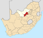
GaMogopa
Appearance
GaMogopa | |
|---|---|
| Coordinates: 26°6′12″S 26°49′30″E / 26.10333°S 26.82500°E | |
| Country | South Africa |
| Province | North West |
| District | Dr Kenneth Kaunda |
| Municipality | Ventersdorp |
| Area | |
| • Total | 2.51 km2 (0.97 sq mi) |
| Population (2011)[1] | |
| • Total | 2,856 |
| • Density | 1,100/km2 (2,900/sq mi) |
| Racial makeup (2011) | |
| • Black African | 98.7% |
| • Coloured | 0.8% |
| • White | 0.2% |
| • Other | 0.2% |
| First languages (2011) | |
| • Tswana | 91.2% |
| • Sotho | 2.6% |
| • English | 2.0% |
| • Xhosa | 1.4% |
| • Other | 2.9% |
| Time zone | UTC+2 (SAST) |
| Area code | 018 |
GaMogopa is a 99% Black African village in Dr Kenneth Kaunda District Municipality, North West Province, South Africa. It is situated 25 km north of Ventersdorp. Mogopa[2] as a small village has known bloggers such as Isaac More[3].


