
Koarnjum
Koarnjum | |
|---|---|
Village | |
 Koarnjum church | |
 Location in Leeuwarderadeel municipality | |
 Koarnjum Location in the Netherlands | |
| Coordinates: 53°15′N 5°47′E / 53.250°N 5.783°E | |
| Country | |
| Province | |
| Municipality | |
| Population (2017) | |
| • Total | 370 |
| Time zone | UTC+1 (CET) |
| • Summer (DST) | UTC+2 (CEST) |
| Postal code | 9056 |
| Telephone area | 058 |
Koarnjum is a village in the municipality of Leeuwarden (Friesland province), in the Netherlands. The village is situated between Jelsum and Britsum and a population of around 370 in January 2017.[1]
History
Cornjum was served by a station on the North Friesland Railway which opened in 1901 and closed to passengers in July 1936, before reopening to passengers in May 1940 and closing to passengers again in December 1940. The line finally closed in 1997.
Before 2018, the village was part of the Leeuwarderadeel municipality.
Notable Landmarks
The old mansion Martenastate in Cornjum was demolished around 1900 and replaced by a small fantasy castle.
-
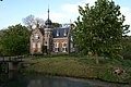 Martenastate

References
- ^ Kerncijfers wijken en buurten 2017 - CBS Statline
External links
| International | |
|---|---|
| National | |
This Friesland location article is a stub. You can help Wikipedia by expanding it. |