
Quebec Route 275
Route 275 | ||||
|---|---|---|---|---|
 | ||||
| Route information | ||||
| Length | 132 km[1] (82 mi) | |||
| Major junctions | ||||
| South end | ||||
| North end | ||||
| Location | ||||
| Country | Canada | |||
| Province | Quebec | |||
| Major cities | Saint-Romuald (Lévis), Saint-Jean-Chrysostome (Lévis), Saint-Côme–Linière | |||
| Highway system | ||||
| ||||

Route 275 is a two-lane north/south highway in the Chaudière-Appalaches region in the province of Quebec. Its northern terminus is in Saint-Romuald, now part of Lévis at the junction of Route 132 and its southern terminus is in Saint-Côme–Linière at the junction of Route 173.
Towns along Route 275
.jpg)
- Saint-Côme–Linière
- Saint-Zacharie
- Saint-Prosper
- Saint-Benjamin
- Saint-Odilon-de-Cranbourne
- Sainte-Marguerite
- Sainte-Hénédine
- Saint-Isidore
- Saint-Jean-Chrysostome (Lévis)
- Saint-Romuald (Lévis)
-
 Entering Saint-Prosper.
 -
 Route 275 through Saint-Odilon describes a straight line over hills and valleys.
 -
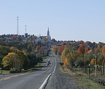
 Route 275 in Frampton.


See also
References
- ^ Ministère des transports, "Distances routières", page (?), Les Publications du Québec, 2005
External links
- Route 273 on Google Maps
- Provincial Route Map (Courtesy of the Quebec Ministry of Transportation) (in French)
This Quebec road, road transport or highway-related article is a stub. You can help Wikipedia by expanding it. |