Mount Nelly
Appearance
| Nelly | |
|---|---|
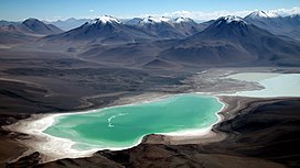
 Laguna Verde and Laguna Blanca in front of Mount Nelly (on the left, snow covered) and Mount Laguna Verde (on the right) as seen from the peak of Licancabur | |
| Highest point | |
| Elevation | 5,676 m (18,622 ft)[1] |
| Coordinates | 22°41′55″S 67°45′17″W / 22.69861°S 67.75472°W[1] |
| Geography | |
| Location | Bolivia, Potosí Department, Sur Lípez Province, San Pablo de Lípez Municipality, Quetena Grande Canton |
| Parent range | Andes, Cordillera Occidental |
| Geology | |
| Mountain type | Stratovolcano |
Nelly (Spanish Cerro Nelly) is a stratovolcano in the Andes located in the Cordillera Occidental of Bolivia, about 5,676 m (18,622 ft) high. It is situated within the Eduardo Avaroa Andean Fauna National Reserve, north east of the Licancabur volcano, Laguna Verde and Laguna Blanca and next to Mount Laguna Verde in the Potosí Department, Sur Lípez Province, San Pablo de Lípez Municipality, Quetena Grande Canton.[2]
See also
References

