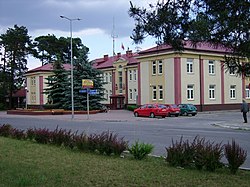
Pionki
Pionki | |
|---|---|
 Pionki Town Hall | |
| Coordinates: 51°29′N 21°27′E / 51.483°N 21.450°E | |
| Country | |
| Voivodeship | Masovian |
| County | Radom |
| Gmina | Pionki (urban gmina) |
| Established | 18th century |
| Town rights | 1954 |
| Government | |
| • Mayor | Robert Kowalczyk |
| Area | |
| • Total | 18.34 km2 (7.08 sq mi) |
| Population (2016) | |
| • Total | 18,846 |
| • Density | 1,000/km2 (2,700/sq mi) |
| Time zone | UTC+1 (CET) |
| • Summer (DST) | UTC+2 (CEST) |
| Postal code | 26-670 to 26-675 |
| Area code | +48 048 |
| Car plates | WRA |
| Website | http://www.pionki.pl |
Pionki [ˈpʲɔŋkʲi] is a town in Radom County, Masovian Voivodeship, central Poland with 18 846 inhabitants (2016). Previously it was in Radom Voivodeship (1975-1998) and in Kielce Voivodeship (until 1975). Surrounded by the Kozienice Wilderness, Pionki is located in northern part of historic province of Lesser Poland, 20 kilometres (12 miles) from Radom, and 105 kilometres (65 miles) from Warsaw. The town is home to a sports club Proch, established in 1926.
Until 1932, the settlement was a village named Zagożdżon. Its development was closely associated with Chemical Plant Pronit (Zakłady Tworzyw Sztucznych ZTS Pronit), founded in 1923 as State Manufacturer of Gunpowder and Explosives (Państwowa Wytwórnia Prochu i Materiałów Kruszących PWPiMK). Originally, it was an arms factory, which manufactured explosives, and its location was deliberate - next to the village of Zagożdżon, among the forests and swamps of the Kozienice Wilderness, away from main population centers, and along the strategic rail line Radom - Dęblin. After World War II, the Chemical Plant Pronit began manufacturing glue, plastic, as well as gramophone records.
In the interbellum period, Pionki prospered due to government contracts, as demand for explosives of its chemical plant was high. In 1925, a new rail station was opened, three years later - a post office. In 1929, overhead power line joined Pionki with Skarżysko-Kamienna, and a vocational high school was opened. Later on, a new police station was opened, and in 1937, the construction of a hospital was initiated.
In 1939, Pionki was bombed by the Luftwaffe and the Germans occupied the town. In addition to the other destruction, the Germans brutalized the small Jewish population of around 200. Many were conscripted for slave labor including the most dangerous jobs at a local gunpowder faculty. In late 1941, a ghetto was established and Jews from surrounding towns brought there, resulting in a population of around 700 and such severe overcrowding that some people lived in the street. Some local Poles were helpful in providing food for the impoverished residents. In August 1942, some of the healthier workers were sent to live at a work camp while the rest were sent to the Zwolen ghetto and then, in late September, to Treblinka. They were immediately murdered there by gassing. The number of Pionki Jewish survivors was small, but at least eight.[1]
In 1919 - 1939, and after the war, until 1975, Pionki belonged to Kielce Voivodeship. Punk rock band The Bill comes from Pionki. Polish musician Andrzej Piaseczny was born in there.
Pionki are twinned with: Breaza and Vyshneve
References
- ^ Megargee, Geoffrey (2012). Encyclopedia of Camps and Ghettos. Bloomington, Indiana: University of Indiana Press. p. Volume II, 278–279; 355–356. ISBN 978-0-253-35599-7.
External links
- Jewish Community in Pionki on Virtual Shtetl


