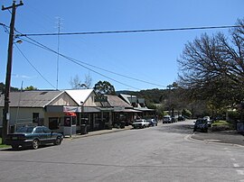
Blackwood, Victoria
| Blackwood Victoria | |||||||||||||||
|---|---|---|---|---|---|---|---|---|---|---|---|---|---|---|---|
 Main street | |||||||||||||||
| Coordinates | 37°28′S 144°18′E / 37.467°S 144.300°E | ||||||||||||||
| Population | 295 (2016 census)[1] | ||||||||||||||
| Established | 1855 | ||||||||||||||
| Postcode(s) | 3458 | ||||||||||||||
| Elevation | 560 m (1,837 ft) | ||||||||||||||
| Location |
| ||||||||||||||
| LGA(s) | Shire of Moorabool | ||||||||||||||
| State electorate(s) | Macedon | ||||||||||||||
| Federal division(s) | Ballarat | ||||||||||||||
| |||||||||||||||
Blackwood is a township in Victoria, Australia. The township is located on the Lerderderg River, 89 kilometres north west of the state capital, Melbourne. Situated in The Wombat State Forest. Blackwood is in the Shire of Moorabool local government area and had a population of 295 at the 2016 census.[1] The town currently consists of a pub, a coffee roasting company & cafe, a post office / takeaway store, an antique market store (open by chance), a design studio, various holiday cottages, a holiday park, mineral spring, bed and breakfast accommodation, Blackwood Ridge Nursery & Garden and The Garden of St Erth.
The township was founded in 1855 during the Victorian gold rush and shortly after had a population of around 13,000. The Post Office opened on 22 September 1855 at what is today known as “Blackwood House” and was known as Mount Blackwood post office until 1921.[2]
Attractions for tourists and visitors include outdoor activities: bushwalking, 4WD and camping in the Lerderderg State Park and Wombat State Forest. The Coffee Roaster, Garden of St Erth, Blackwood Mineral Springs, Holiday Park, Blackwood Ridge Nursery Gardens & Restaurant, Frogmoore gardens, Blackwood Hat Shop, miners' cottages from the 1860s and Mount Blackwood. Mount Blackwood, a short drive away is an extinct volcano offering panoramic views of the surrounding area on clear days. The remnants of Wheeler's Tramway, a former Blackwood sawmill tramway in the Wombat State Forest, are listed on the Victorian Heritage Register for their archaeological significance.[3]
The annual Easter Carnival & wood chop, is an important annual event, attracting mostly locals and those that have a family connection to the settlement; but no longer live locally. Held annually on Easter Saturday, it's starting to attract tourism.
The town attracts professionals, entrepreneurs, tradespeople, musicians, creatives, power drinkers, professional gossips and young families; who all live together in an allegedly friendly community.

The township attracts thousands of tourists to the area every year.
References
- ^ a b Australian Bureau of Statistics (27 June 2017). "Blackwood (State Suburb)". 2016 Census QuickStats. Retrieved 9 July 2014.
- ^ Premier Postal History, Post Office List, retrieved 11 April 2008
- ^ "Wheeler's Tramway (H2015)". Victorian Heritage Register. Heritage Victoria. Retrieved 7 July 2014.
External links
- Community site
- The Age travel site
- Garden of St Erth web site
- [http://www.blackwoodpublishing.com/home/history-of-blackwood-victoria/ Genealogical and early history of Blackwood
Victoria]


