
Webster Township, Michigan
Webster Township, Michigan | |
|---|---|
 Township Hall on Webster Church Road | |
 Location within Washtenaw County | |
 Webster Township Location within the state of Michigan | |
| Coordinates: 42°22′40″N 83°50′18″W / 42.37778°N 83.83833°W | |
| Country | United States |
| State | Michigan |
| County | Washtenaw |
| Established | 1833 |
| Government | |
| • Supervisor | John Kingsley |
| • Clerk | Barb Calleja |
| Area | |
| • Total | 35.9 sq mi (93.0 km2) |
| • Land | 35.1 sq mi (90.9 km2) |
| • Water | 0.8 sq mi (2.1 km2) |
| Elevation | 922 ft (281 m) |
| Population (2010) | |
| • Total | 6,784 |
| • Density | 190/sq mi (73/km2) |
| Time zone | UTC-5 (Eastern (EST)) |
| • Summer (DST) | UTC-4 (EDT) |
| ZIP code(s) | |
| Area code | 734 |
| FIPS code | 26-85100[1] |
| GNIS feature ID | 1627237[2] |
| Website | Official website |
Webster Township is a civil township of Washtenaw County in the U.S. state of Michigan. Originally settled in the 1820s and 1830s, this small town has a rich history, centered on the picturesque area known locally as "Webster Corners".[3] The township population was 6,784 at the 2010 census.[4]
Geography
According to the United States Census Bureau, the township has a total area of 35.9 square miles (93.0 km2), of which 35.1 square miles (90.9 km2) is land and 0.81 square miles (2.1 km2), or 2.24%, is water.[5]
Demographics
As of the census[1] of 2000, there were 5,198 people, 1,774 households, and 1,491 families residing in the township. The population density was 147.4 per square mile (56.9/km2). There were 1,859 housing units at an average density of 52.7 per square mile (20.4/km2). The racial makeup of the township was 97.19% White, 0.62% African American, 0.31% Native American, 0.87% Asian, 0.25% from other races, and 0.77% from two or more races. Hispanic or Latino of any race were 1.15% of the population.
There were 1,774 households out of which 44.3% had children under the age of 18 living with them, 77.6% were married couples living together, 4.1% had a female householder with no husband present, and 15.9% were non-families. 11.7% of all households were made up of individuals and 3.4% had someone living alone who was 65 years of age or older. The average household size was 2.93 and the average family size was 3.20.
In the township the population was spread out with 30.5% under the age of 18, 4.0% from 18 to 24, 29.4% from 25 to 44, 29.0% from 45 to 64, and 7.1% who were 65 years of age or older. The median age was 39 years. For every 100 females, there were 104.8 males. For every 100 females age 18 and over, there were 102.2 males.
The median income for a household in the township was $90,830, and the median income for a family was $97,828. Males had a median income of $62,384 versus $40,859 for females. The per capita income for the township was $35,883. None of the families and 0.8% of the population were living below the poverty line, including no under eighteens and none of those over 64.
Gallery
-
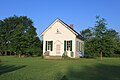 Old Town Hall, Webster Church Rd.
 -
 Old Town Hall historical marker
 -
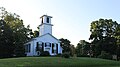 Webster Church, Webster Church Rd.
 -
 Webster Church historical marker
 -
 St. Joseph Catholic Church, Mast Rd.
 -
 Farm on Webster Church Rd.
 -
 Wheeler Blacksmith Shop, Webster Church Rd.


References
- ^ a b "U.S. Census website". United States Census Bureau. Retrieved 2008-01-31.
- ^ U.S. Geological Survey Geographic Names Information System: Webster Township, Michigan
- ^ "Webster Corners". Retrieved 2010-06-07.
- ^ "Profile of General Population and Housing Characteristics: 2010 Demographic Profile Data (DP-1): Webster township, Washtenaw County, Michigan". United States Census Bureau. Retrieved July 10, 2012.
- ^ "Geographic Identifiers: 2010 Demographic Profile Data (G001): Webster township, Washtenaw County, Michigan". United States Census Bureau. Retrieved July 10, 2012.
Municipalities and communities of Washtenaw County, Michigan, United States | ||
|---|---|---|
| Cities |  | |
| Village | ||
| Charter townships | ||
| Civil townships | ||
| CDPs | ||
| Other communities |
| |
| Defunct | ||
| Ghost towns |
| |
| Footnotes | ‡This populated place also has portions in an adjacent county or counties | |