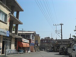
Tömük
Tömük | |
|---|---|
Town | |
 | |
| Coordinates: 36°40′N 34°23′E / 36.667°N 34.383°E | |
| Country | |
| Region | Mediterranean |
| Province | Mersin |
| District | Erdemli |
| Government | |
| • Mayor | Derviş Yıldırım (Justice and Development Party, AKP) |
| Population (2012) | |
• Total | 10,907 |
| Time zone | UTC+2 (EET) |
| • Summer (DST) | UTC+3 (EEST) |
| Postal code | 33350 |
| Area code | 0-324 |
| Website | www.yerelnet.org.tr |
Tömük is a town in Mersin Province, Turkey.
Geography
Tömük is in the rural area of Erdemli district, which is a part of Mersin Province. Although the midtown is 3 km (1.9 mi) north of the seaside, newer quarters of the town are founded at the seaside just on the main highway ![]() D.400 connecting Mersin to the west. Highway distance to Mersin is 27 km (17 mi) and to Erdemli is 12 km (7.5 mi). The population was 10 907.[1] as of 2012.
D.400 connecting Mersin to the west. Highway distance to Mersin is 27 km (17 mi) and to Erdemli is 12 km (7.5 mi). The population was 10 907.[1] as of 2012.
History

The earliest settlers were the members of a Turkmen tribe of a certain Elvan Bey in the 14th century. They founded the village of Elvanlı a few kilometers east of Tömük. Tömük was a just a hamlet used occasionally by the Elvanlı residents. But, early in the last years of the 18th century, people from other villages began to populate Tömük. In 1969, Tömük was declared a township.[2]
Economy
The major economic activity is citrus horticulture. Olive, tomato and green pepper are among the other important crops. Services for summer houses in the coastal band also contribute to town economy.
References
- ^ Turksat Archived September 27, 2013, at the Wayback Machine
- ^ "Mayor's page" (in Turkish). www.tomuk.bel.tr.

