Shellman, Georgia
Shellman, Georgia | |
|---|---|
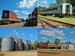
 Shellman in 2012. | |
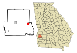
 Location in Randolph County and the state of Georgia | |
| Coordinates: 31°45′31″N 84°36′46″W / 31.75861°N 84.61278°W | |
| Country | United States |
| State | Georgia |
| County | Randolph |
| Area | |
• Total | 3.15 sq mi (8.16 km2) |
| • Land | 3.15 sq mi (8.16 km2) |
| • Water | 0.00 sq mi (0.00 km2) |
| Elevation | 384 ft (117 m) |
| Population (2010) | |
• Total | 1,083 |
• Estimate (2019)[2] | 933 |
| • Density | 296.28/sq mi (114.38/km2) |
| Time zone | UTC-5 (Eastern (EST)) |
| • Summer (DST) | UTC-4 (EDT) |
| ZIP codes | 39886 |
| Area code | 229 |
| FIPS code | 13-70120[3] |
| GNIS feature ID | 0356533[4] |
| Website | http://www.shellmanga.com/ |
Shellman is a city in Randolph County, Georgia, United States. The population was 1,083 at the 2010 census. Buildings in the commercial center have been designated as an historic district and listed in 1985 on the National Register of Historic Places.
Geography
Shellman is located at 31°45′31″N 84°36′46″W / 31.75861°N 84.61278°W (31.758473, -84.612731).[5]
According to the United States Census Bureau, the city has a total area of 3.2 square miles (8.3 km2), all land.
History
The community is named after W.F. Shellman, who had donated funds to a local school.[6]
The Shellman Historic District is listed on the National Register of Historic Places.[7]
Demographics
| Census | Pop. | Note | %± |
|---|---|---|---|
| 1890 | 462 | — | |
| 1900 | 584 | 26.4% | |
| 1910 | 985 | 68.7% | |
| 1920 | 1,074 | 9.0% | |
| 1930 | 1,117 | 4.0% | |
| 1940 | 1,063 | −4.8% | |
| 1950 | 1,090 | 2.5% | |
| 1960 | 1,050 | −3.7% | |
| 1970 | 1,166 | 11.0% | |
| 1980 | 1,254 | 7.5% | |
| 1990 | 1,162 | −7.3% | |
| 2000 | 1,166 | 0.3% | |
| 2010 | 1,083 | −7.1% | |
| 2019 (est.) | 933 | [2] | −13.9% |
| U.S. Decennial Census[8] | |||
As of the census[3] of 2000, there were 1,166 people, 407 households, and 297 families residing in the city. The population density was 369.8 people per square mile (142.9/km2). There were 465 housing units at an average density of 147.5 per square mile (57.0/km2). The racial makeup of the city was 30.53% White, 68.87% African American, 0.09% Native American, 0.17% Pacific Islander, and 0.34% from two or more races. Hispanic or Latino of any race were 0.43% of the population.
There were 407 households out of which 34.2% had children under the age of 18 living with them, 39.8% were married couples living together, 27.5% had a female householder with no husband present, and 27.0% were non-families. 24.6% of all households were made up of individuals and 13.5% had someone living alone who was 65 years of age or older. The average household size was 2.86 and the average family size was 3.45.
In the city, the population was spread out with 32.5% under the age of 18, 10.4% from 18 to 24, 23.1% from 25 to 44, 21.3% from 45 to 64, and 12.8% who were 65 years of age or older. The median age was 32 years. For every 100 females, there were 84.2 males. For every 100 females age 18 and over, there were 71.5 males.
The median income for a household in the city was $20,950, and the median income for a family was $29,583. Males had a median income of $27,875 versus $18,462 for females. The per capita income for the city was $11,267. About 30.1% of families and 33.2% of the population were below the poverty line, including 45.1% of those under age 18 and 29.5% of those age 65 or over.
Notable people
- Thomas Davis, NFL defensive player, grew up in Shellman.
- Donnell Harvey, former NBA athlete, grew up here.
- Diadourius Boudleaux Bryant, part of the prolific songwriting team of Felice and Boudleaux Bryant, was born in Shellman in 1920.
- Paul C. Broun Sr., Georgia State Senator was born here in 1916
Gallery
-
The Shellman Historic District was added to the National Register of Historic Places.
-
Shellman Post Office (ZIP code: 39886)
-
Shellman Volunteer Fire Department
References
- ^ "2019 U.S. Gazetteer Files". United States Census Bureau. Retrieved July 9, 2020.
- ^ a b "Population and Housing Unit Estimates". United States Census Bureau. May 24, 2020. Retrieved May 27, 2020.
- ^ a b "U.S. Census website". United States Census Bureau. Retrieved 2008-01-31.
- ^ "US Board on Geographic Names". United States Geological Survey. 2007-10-25. Retrieved 2008-01-31.
- ^ "US Gazetteer files: 2010, 2000, and 1990". United States Census Bureau. 2011-02-12. Retrieved 2011-04-23.
- ^ Krakow, Kenneth K. (1975). Georgia Place-Names: Their History and Origins (PDF). Macon, GA: Winship Press. p. 204. ISBN 0-915430-00-2.
- ^ Carolyn Brooks (April 8, 1985). "National Register of Historic Places Inventory/Nomination: Shellman Historic District". National Park Service. Retrieved August 15, 2017. (includes map). With 47 photos from 1984.
- ^ "Census of Population and Housing". Census.gov. Retrieved June 4, 2015.


