Callemondah
| Callemondah Gladstone, Queensland | |||||||||||||||
|---|---|---|---|---|---|---|---|---|---|---|---|---|---|---|---|
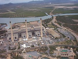
 Gladstone Powerhouse with the Calliope River beyond, 2005 | |||||||||||||||
| Coordinates | 23°50′34″S 151°12′51″E / 23.8427°S 151.2141°E | ||||||||||||||
| Population | 18 (2016 census)[1] | ||||||||||||||
| • Density | 0.352/km2 (0.912/sq mi) | ||||||||||||||
| Postcode(s) | 4680 | ||||||||||||||
| Area | 51.1 km2 (19.7 sq mi) | ||||||||||||||
| LGA(s) | Gladstone Region | ||||||||||||||
| State electorate(s) | Gladstone | ||||||||||||||
| Federal division(s) | Flynn | ||||||||||||||
| |||||||||||||||
Callemondah is a coastal suburb of Gladstone in the Gladstone Region, Queensland, Australia.[2]
Geography
The Calliope River forms the south-western boundary of the suburb before flowing north through the suburb into Gladstone Harbour. Auckland Inlet forms its eastern boundary separating it from Gladstone Central.[3]
The land use is predominantly industrial with a number of coal port facilities with associated stockpiles, the NRG Gladstone Powerhouse (the largest in Queensland), railway servicing facilities and numerous other industrial businesses.[3]
The Callemondah railway station is located on the southern boundary of the suburb. It is on the North Coast railway line, the Moura railway line, the Blackwater railway line and a number private rail lines within Callemondah servicing various industrial facilities.[3]
History
The suburb takes its name from the railway station which was assigned in August 1967 by Queensland Railways Department to their locomotive servicing facility, using an Aboriginal word (probably from a New South Wales area), meaning plenty of hills.[2]
Education
Central Queensland University operates its Gladstone Marina campus on Bryan Jordan Drive in the north-east tip of Callemondah which is linked by a bridge across the Auckland Inlet to Gladstone Central. As the name suggests, the campus is adjacent to the Gladstone Marina.[4]
Fishery
Lake Callemondah is an artificial lake adjacent to Auckland Inlet but separated from it by a rock and concrete wall. The lake receives stormwater run-off from the roofs and streets of the local area. In 1999 barramundi fingerlings were first introduced into the lake. As the fish mature, they are able to migrate into Auckland Inlet and beyond. Up to 2,800 new fingerlings are added to the lake each year. By tagging the fish, it has been established most of the mature fish stay in the Gladstone area, but one has been found up 36 km away in the Boyne River.[5][6]
References
- ^ Australian Bureau of Statistics (27 June 2017). "Callemondah (SSC)". 2016 Census QuickStats. Retrieved 28 February 2018.
- ^ a b "Callemondah – suburb in Gladstone Region (entry 49128)". Queensland Place Names. Queensland Government. Retrieved 29 December 2017.
- ^ a b c "Queensland Globe". State of Queensland. Retrieved 27 February 2018.
- ^ "Gladstone Marina - CQU". Central Queensland University. Archived from the original on 18 July 2017. Retrieved 28 February 2018.
- ^ Seierup, Greg (April 2007). "Lake Callemondah a run-away success". Fishing Monthly. Archived from the original on 21 September 2011. Retrieved 28 February 2018.
- ^ Sawynok, Bill; Platten, John (January 2007). "Lake Callemondah Tracking Stocked Barramundi" (PDF). Infofish Australia. Archived (PDF) from the original on 2 March 2017. Retrieved 28 February 2018.
External links
![]() Media related to Callemondah, Queensland at Wikimedia Commons
Media related to Callemondah, Queensland at Wikimedia Commons

