
Curry, Walker County, Alabama
Curry, Alabama | |
|---|---|
 Curry, Alabama  Curry, Alabama | |
| Coordinates: 33°57′13″N 87°12′52″W / 33.95361°N 87.21444°W | |
| Country | United States |
| State | Alabama |
| County | Walker |
| Elevation | 623 ft (190 m) |
| Time zone | UTC-6 (Central (CST)) |
| • Summer (DST) | UTC-5 (CDT) |
| Area code(s) | 205, 659 |
| GNIS feature ID | 159474[1] |
Curry is an unincorporated community in north-central Walker County Alabama, United States.[1] It is the closest community to the Lewis Smith Lake dam. Curry is served by Alabama State Route 257, which is simply known as Curry Highway by locals.
Education
Curry has three primary schools. Curry Elementary, Curry Middle, And Curry High. Curry High School is a 5A school, serving grades 9-12.[2] The school colors are Blue and Gold with the mascot being the Yellow Jacket. It is a member of the Walker County Board of Education.[3]
Notable person
- Charles Martin, Alabama politician
References
- ^ a b "Curry, Alabama". Geographic Names Information System. United States Geological Survey, United States Department of the Interior.
- ^ Curry High School
- ^ "Walker County Schools". Archived from the original on 2008-01-02. Retrieved 2007-12-15.
Municipalities and communities of Walker County, Alabama, United States | ||
|---|---|---|
| Cities | 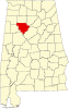 | |
| Towns | ||
| Unincorporated communities | ||
| Footnotes | ‡This populated place also has portions in an adjacent county or counties | |
This Alabama state location article is a stub. You can help Wikipedia by expanding it. |