Lindong
Lindong
林东镇 | |
|---|---|
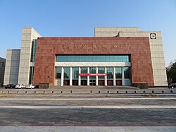
 Liao Shangjing Museum | |
| Coordinates (Lindong town government): 43°58′05″N 119°22′32″E / 43.9681°N 119.3756°E | |
| Country | People's Republic of China |
| Autonomous region | Inner Mongolia |
| Prefecture-level city | Chifeng |
| Banner | Bairin Left Banner |
| Population (2018)[1] | |
| • Total | 68,000 |
| Time zone | UTC+8 (China Standard) |
Lindong (林东镇; 林東鎮; Líndōng Zhèn) is a town in the Balin Left Banner, Chifeng, within the Inner Mongolia Autonomous Region of the People's Republic of China.[2][3] The town has an area of 1,322,000 mu, and a population of 68,000.[2] The town serves as the administrative seat of the Balin Left Banner.[4]
Administrative divisions
Lindong is divided into 33 administrative villages.[5]
Economy
According to the government of the Balin Left Banner, the largest industries in the town are vegetable farming, donkey husbandry, and broom production.[2] In order to promote economic growth, the Banner government has launched a plan to expand agricultural facilities, construct a dam, and build a photovoltaic power plant within Lindong.[2]
Transportation
National Highway 305 currently ends in the town, however, as of March 2020, the Banner government is working on a plan to extend it to the township of Xiahuofang.[6] Multiple commercial bus providers service a route from Lindong to Beijing, which is approximately 780 kilometers in length.[7][8]
References
- ^ 林东镇简介 [Lindong Introduction] (in Simplified Chinese). 巴林左旗人民政府. 29 February 2020. Retrieved 5 March 2020.
林东镇辖33个行政村及1处脱贫产业园区,总面积132.2万亩,总人口6.8万人
- ^ a b c d 林东镇简介. www.blzq.gov.cn (in Chinese). Retrieved 2020-03-05.
{{cite web}}: CS1 maint: url-status (link) - ^ 2019年统计用区划代码 (in Chinese). National Bureau of Statistics of China. 2019. Archived from the original on 2020-08-12. Retrieved 2020-08-12.
- ^ 巴林左旗概况地图. xzqh.org (in Chinese). 2013-04-09. Archived from the original on 2020-08-12. Retrieved 2020-08-12.
- ^ 2019年统计用区划代码和城乡划分代码 (in Chinese). National Bureau of Statistics of China. 2019. Archived from the original on 2020-08-12. Retrieved 2020-08-12.
- ^ 国道305线林东至下伙房段公路工程施工图勘察设计、勘测定界、线内征地分户及土地组件报批服务进行公开招标 - 部门动态 - 巴林左旗人民政府. www.blzq.gov.cn (in Chinese). Chifeng Bairin Left Banner People's Government. 2020-03-03. Archived from the original on 2020-08-12. Retrieved 2020-08-12.
- ^ 六里桥长途汽车站的全部线路. 车次网 (in Chinese).
{{cite web}}: CS1 maint: url-status (link) - ^ 六里桥长途汽车站 至 林东. 汽车站 (in Chinese).
{{cite web}}: CS1 maint: url-status (link)

