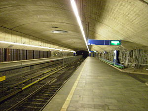
Ellingsrudåsen station
 | |
| General information | |
| Location | Ellingsrud, Oslo Norway |
| Coordinates | 59°56′9″N 10°54′59″E / 59.93583°N 10.91639°E |
| Elevation | 165.2 m (542 ft) |
| Owned by | Sporveien |
| Operated by | Sporveien T-banen |
| Line(s) | Furuset Line |
| Distance | 12.0 km (7.5 mi) from Stortinget |
| Construction | |
| Structure type | Underground |
| History | |
| Opened | 8 November 1981 |
Ellingsrudåsen is a subway station on the Oslo Metro, located at Ellingsrud in the Alna borough. Since its opening on 8 November 1981, it has been the end station for the Furuset Line (Line 2). Ellingsrudåsen is a mostly residential area. Above the station is a small shopping centre.
Ellingsrudåsen is located deep underground, and elevators are the usual means of getting to and from the station. Like Romsås, Ellingsrudåsen has natural mountain walls.
References
External links
![]() Media related to Ellingsrudåsen stasjon at Wikimedia Commons
Media related to Ellingsrudåsen stasjon at Wikimedia Commons
Line 2
| align=center style="background:#Template:Oslo Metro color;" | Line 2: Østerås – Stortinget – Ellingsrudåsen | |
|
Østerås • Lijordet • Eiksmarka • Ekraveien • Røa • Hovseter • Holmen • Makrellbekken • Smestad • Borgen • Majorstuen • Nationaltheatret • Stortinget • Jernbanetorget • Grønland • Tøyen • Ensjø • Helsfyr • Brynseng • Hellerud • Tveita • Haugerud • Trosterud • Lindeberg • Furuset • Ellingsrudåsen | |

