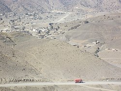
Ghulam Khan
Appearance
Ghulam Khan
غلام خان | |
|---|---|
Town | |
 | |
| Coordinates: 33°08′38″N 70°01′26″E / 33.14389°N 70.02389°E | |
| Countries | |
| Provinces | Khyber Pakhtunkhwa Khost Province |
| Districts | North Waziristan Khost |
| Tehsil | Ghulam Khan |
| Elevation | 2,010 m (6,590 ft) |
| Population | |
| • Total | 2,553 |
| Time zone | UTC+5 (PST) |
Ghulām Khān (Pashto/Urdu: غلام خان) is a border town between Pakistan and Afghanistan. One part of the town sits in Khyber Pakhtunkhwa of Pakistan, and the other half in Khost Province of Afghanistan.[2][3] It is the third busiest border crossing between the two countries, after Torkham and Chaman. The people in the area are all ethnic Pashtuns of the same sub-tribes or clans.
References
- ^ "POPULATION AND HOUSEHOLD DETAIL FROM BLOCK TO DISTRICT LEVEL: FATA (NORTH WAZIRISTAN)" (PDF). www.pbscensus.gov.pk. 2018-01-03. Archived from the original (PDF) on 2018-04-03. Retrieved 2018-04-02.
- ^ "Waziristan Residents Say Strict Customs Hinder Trade With Afghanistan". Gandahar. September 24, 2018. Retrieved 2019-03-29.
- ^ "Tribesmen, business communities welcome Pak-Afghan Ghulam Khan border opening". Pakistan Today. May 1, 2018. Retrieved 2019-03-29.
Images
-
Afghan National Police (ANP) on the Afghanistan side of the border crossing in 2007
-
Afghan police speaking with a driver in 2007


