Pantanos de Centla
| Pantanos de Centla | |
|---|---|
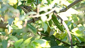
 Brown basilisk (toloque rayado) in the Pantanos de Centla | |
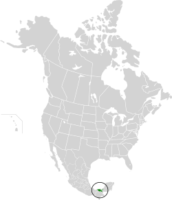
 Location map of the Pantanos de Centla | |
| Ecology | |
| Realm | Neotropical |
| Biome | tropical and subtropical moist broadleaf forests |
| Borders | |
| Geography | |
| Area | 17,028 km2 (6,575 sq mi) |
| Country | Mexico |
| States | |
| Conservation | |
| Conservation status | Critical/endangered |
| Protected | 5,644 km² (33%)[1] |
| Designations | |
|---|---|
| Official name | Reserva de la Biosfera Pantanos de Centla |
| Designated | 22 June 1995 |
| Reference no. | 733[2] |


The Pantanos de Centla (Centla swamps) is a tropical moist forest ecoregion in southern Mexico, which includes seasonally flooded forests and wetlands, in the summer.
Setting
The ecoregion covers an area of 17,200 square kilometers (6,600 sq mi) in the states of Tabasco and Campeche. The Centla swamps occupy the delta of the Usumacinta and Grijalva rivers, which empty into the Gulf of Mexico and the Laguna de Términos through numerous distributaries. The ecoregion includes year-round wetlands, and freshwater swamp forests which are inundated during the summer rainy season.
The Usumacinta mangroves lie in the brackish-water zone between the Centla swamps and the open water of the Laguna de Términos and the Gulf. The Petén-Veracruz moist forests lie to the west and south, and the Yucatan moist forests lie to the east.
Flora
The largest plant community in the ecoregion is semi-evergreen forest. Wetland plant communities, including marshlands and freshwater swamp forests, cover over a third of the region.
The predominant trees in the semi-evergreen forest include black olive tree (Bucida buceras) and logwood (Haematoxylum campechianum), with Spondias mombin, Tabebuia rosea, Lonchocarpus hondurensis, bitter angelim (Vatairea lundelii), gumbo-limbo (Bursera simaruba), guanandis (Calophyllum brasiliense), mahogany (Swietenia macrophylla), and cedar (Cedrela odorata).[3]
Fauna
Some large animals in the ecoregion include Morelet's crocodile (Crocodylus moreleti), jaguar (Panthera onca), mantled howler monkey (Alouatta palliata), and tropical gar or pejelagarto (Atractosteus tropicus).[4]
230 species of birds have been recorded, of which 63% are permanent residents, 23% winter residents, 4% transitory, and 10% do not have a defined seasonality.[4] The ecoregion's wetlands are home to many water birds, including jabiru stork (Jabiru mycteria), Maguari stork (Ciconia maguari), boat-billed heron or páspaque (Cochlearius cochlearius), ruddy ground dove (Columbina talpacoti), Muscovy duck (Cairina moschata), black-bellied whistling duck (Dendrocygna autumnalis), pied-billed grebe (Podilymbus podiceps), peregrine falcon (Falco peregrinus), and white ibis (Eudocimus albus).[3]
Conservation and threats
A 2017 assessment found that 5,644 km², or 33%, of the ecoregion is in protected areas.[1] The largest protected area is Pantanos de Centla Biosphere Reserve, which was established in 2006.
References
- ^ a b Eric Dinerstein, David Olson, et al. (2017). An Ecoregion-Based Approach to Protecting Half the Terrestrial Realm, BioScience, Volume 67, Issue 6, June 2017, Pages 534–545; Supplemental material 2 table S1b. [1]
- ^ "Reserva de la Biosfera Pantanos de Centla". Ramsar Sites Information Service. Retrieved 25 April 2018.
- ^ a b "Pantanos de Centla Biosphere Reserve, Mexico". UNESCO. Last updated December 2018. Accessed 13 August 2020. [2]
- ^ a b BirdLife International (2020) Important Bird Areas factsheet: Pantanos de Centla. Accessed 13 August 2020. [3]
External links
- World Wildlife Fund, ed. (2001). "Pantanos de Centla". WildWorld Ecoregion Profile. National Geographic Society. Archived from the original on 2010-03-08.
- "Pantanos de Centla". Terrestrial Ecoregions. World Wildlife Fund.
- Conservation Plan for the Pantanos de Centla Biosphere Reserve and Laguna de Términos Flora and Fauna Protection Area
