
Lauchhammer
Lauchhammer | |
|---|---|
 Church of Christ, the King | |
 Coat of arms | |
Location of Lauchhammer within Oberspreewald-Lausitz district  | |
 Lauchhammer  Lauchhammer | |
| Coordinates: 51°30′00″N 13°48′00″E / 51.50000°N 13.80000°E | |
| Country | Germany |
| State | Brandenburg |
| District | Oberspreewald-Lausitz |
| Subdivisions | 5 Stadt- und 2 Ortsteile |
| Government | |
| • Mayor | Roland Pohlenz |
| Area | |
| • Total | 88.43 km2 (34.14 sq mi) |
| Highest elevation | 160 m (520 ft) |
| Lowest elevation | 94 m (308 ft) |
| Population (2022-12-31)[1] | |
| • Total | 14,143 |
| • Density | 160/km2 (410/sq mi) |
| Time zone | UTC+01:00 (CET) |
| • Summer (DST) | UTC+02:00 (CEST) |
| Postal codes | 01979 |
| Dialling codes | 03574 |
| Vehicle registration | OSL |
| Website | www.lauchhammer.de |
Lauchhammer (Lower Sorbian: Łuchow) is a town in the Oberspreewald-Lausitz district, in southern Brandenburg, Germany. It is situated on the Black Elster river, approx. 17 km west of Senftenberg, and 50 km north of Dresden.
Demography
-
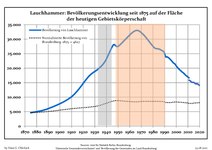 Development of Population since 1875 within the Current Boundaries (Blue Line: Population; Dotted Line: Comparison to Population Development of Brandenburg state; Grey Background: Time of Nazi rule; Red Background: Time of Communist rule)
 -
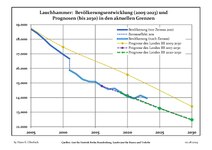 Recent Population Development and Projections (Population Development before Census 2011 (blue line); Recent Population Development according to the Census in Germany in 2011 (blue bordered line); Official projections for 2005-2030 (yellow line); for 2014-2030 (red line); for 2017-2030 (scarlet line)


|
|
|
Transport
Lauchhammer lies on the Węgliniec–Roßlau railway and offers connections to Leipzig and Cottbus.
People
- Klaus Haertter (born 1952)
- Thomas Gumpert (born 1952)
- Annelore Zinke (born 1958)
- Jens Kunath (born 1967)
- Annett Neumann (born 1970)
- Mario Veit (born 1973)
- Sebastian Schuppan (born 1986)
- Stefan Härtel (born 1988)
- Martin Zurawsky (born 1990)
- Danny Breitfelder (born 1997)
References
- ^ "Bevölkerungsentwicklung und Bevölkerungsstandim Land Brandenburg Dezember 2022" (PDF). Amt für Statistik Berlin-Brandenburg (in German). June 2023.
- ^ Detailed data sources are to be found in the Wikimedia Commons.Population Projection Brandenburg at Wikimedia Commons
Towns and municipalities in Oberspreewald-Lausitz | ||
|---|---|---|
 | ||
| International | |
|---|---|
| National | |
| Geographic | |
This Brandenburg location article is a stub. You can help Wikipedia by expanding it. |