
Carenero
Carenero | |
|---|---|
Barrio | |
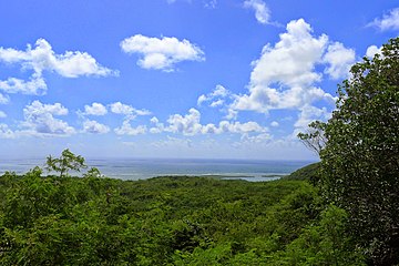
 View of Caña Gorda sector in Carenero | |
 Location of Carenero within the municipality of Guánica shown in red | |
 Carenero Location of Puerto Rico | |
| Coordinates: 17°57′33″N 66°53′09″W / 17.959258°N 66.88572°W[1] | |
| Commonwealth | |
| Municipality | |
| Area | |
| • Total | 9.18 sq mi (23.8 km2) |
| • Land | 7.39 sq mi (19.1 km2) |
| • Water | 1.79 sq mi (4.6 km2) |
| Elevation | 495 ft (151 m) |
| Population (2010) | |
| • Total | 2,670 |
| • Density | 361.3/sq mi (139.5/km2) |
| Source: 2010 Census | |
| Time zone | UTC−4 (AST) |
Carenero is a barrio in the municipality of Guánica, Puerto Rico. Its population in 2010 was 2,670.[3][4][5]
Gallery
-
 Welcome to the forest sign
 -
 View of mountains of Carenero
.jpg)

See also
References
- ^ a b "US Gazetteer 2019". US Census. US Government.
- ^ U.S. Geological Survey Geographic Names Information System: Carenero barrio
- ^ Picó, Rafael; Buitrago de Santiago, Zayda; Berrios, Hector H. Nueva geografía de Puerto Rico: física, económica, y social, por Rafael Picó. Con la colaboración de Zayda Buitrago de Santiago y Héctor H. Berrios. San Juan Editorial Universitaria, Universidad de Puerto Rico,1969.
- ^ Gwillim Law (20 May 2015). Administrative Subdivisions of Countries: A Comprehensive World Reference, 1900 through 1998. McFarland. p. 300. ISBN 978-1-4766-0447-3. Retrieved 25 December 2018.
- ^ Puerto Rico:2010:population and housing unit counts.pdf (PDF). U.S. Dept. of Commerce, Economics and Statistics Administration, U.S. Census Bureau. 2010.
External links
This Puerto Rican location article is a stub. You can help Wikipedia by expanding it. |