Navasfrías
Appearance
From Wikipedia, the free encyclopedia
This is an old revision of this page, as edited by Ser Amantio di Nicolao (talk | contribs) at 16:00, 18 August 2020 (Removing from Category:Populated places in the Province of Salamanca using Cat-a-lot). The present address (URL) is a permanent link to this revision, which may differ significantly from the current revision.
Revision as of 16:00, 18 August 2020 by Ser Amantio di Nicolao (talk | contribs) (Removing from Category:Populated places in the Province of Salamanca using Cat-a-lot)
Municipality in Castile and León, Spain
Navasfrías | |
|---|---|
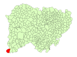
 Location in Salamanca | |
| Coordinates: 40°17′47″N 6°49′12″W / 40.29639°N 6.82000°W / 40.29639; -6.82000 | |
| Country | Spain |
| Autonomous community | Castile and León |
| Province | Salamanca |
| Comarca | Comarca de Ciudad Rodrigo |
| Subcomarca | El Rebollar |
| Government | |
| • Mayor | Esteban Alfoso González (People's Party) |
| Area | |
• Total | 60 km2 (20 sq mi) |
| Elevation | 902 m (2,959 ft) |
| Population (2018)[2] | |
• Total | 460 |
| • Density | 7.7/km2 (20/sq mi) |
| Time zone | UTC+1 (CET) |
| • Summer (DST) | UTC+2 (CEST) |
| Postal code | 37542 |
Navasfrías is a municipality located in the province of Salamanca, Castile and León, Spain. As of 2016 the municipality has a population of 470 inhabitants.[3]
References
- ^ a b "Municipio:Navasfrías". www.lasalina.es. Retrieved 2017-11-02.
- ^ Municipal Register of Spain 2018. National Statistics Institute.
- ^ "Salamanca: Población por municipios y sexo". www.ine.es (in Spanish). Retrieved 2017-11-02.
| Authority control databases: National |
|---|
This article about a location in the province of Salamanca, Spain, is a stub. You can help Wikipedia by expanding it. |


