Topas, Salamanca
Appearance
From Wikipedia, the free encyclopedia
This is an old revision of this page, as edited by Ser Amantio di Nicolao (talk | contribs) at 16:00, 18 August 2020 (Removing from Category:Populated places in the Province of Salamanca using Cat-a-lot). The present address (URL) is a permanent link to this revision, which may differ significantly from the current revision.
Revision as of 16:00, 18 August 2020 by Ser Amantio di Nicolao (talk | contribs) (Removing from Category:Populated places in the Province of Salamanca using Cat-a-lot)
This article is about the Spanish municipality. For other uses, see Topas, Salamanca (disambiguation).
Municipality in Castile and León, Spain
Topas | |
|---|---|
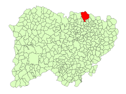
 Location in Salamanca | |
| Coordinates: 41°09′25″N 5°38′02″W / 41.15694°N 5.63389°W / 41.15694; -5.63389 | |
| Country | Spain |
| Autonomous community | Castile and León |
| Province | Salamanca |
| Comarca | La Armuña |
| Government | |
| • Mayor | Julia Rivas (PSOE) |
| Area | |
| • Total | 112 km2 (43 sq mi) |
| Elevation | 824 m (2,703 ft) |
| Population (2018)[2] | |
| • Total | 530 |
| • Density | 4.7/km2 (12/sq mi) |
| Time zone | UTC+1 (CET) |
| • Summer (DST) | UTC+2 (CEST) |
| Postal code | 37799 |
Topas is a municipality located in the province of Salamanca, Castile and León, Spain. As of 2016 the municipality has a population of 554 inhabitants.
References
- ^ a b "Municipio:Topas". www.lasalina.es. Retrieved 2017-10-25.
- ^ Municipal Register of Spain 2018. National Statistics Institute.
This article about a location in the province of Salamanca, Spain, is a stub. You can help Wikipedia by expanding it. |


