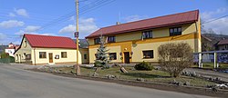
Velké Svatoňovice
Appearance
Velké Svatoňovice | |
|---|---|
 Municipal office | |
| Coordinates: 50°31′57″N 16°1′42″E / 50.53250°N 16.02833°E | |
| Country | |
| Region | Hradec Králové |
| District | Trutnov |
| First mentioned | 1357 |
| Area | |
• Total | 17.36 km2 (6.70 sq mi) |
| Elevation | 394 m (1,293 ft) |
| Population (2020-01-01[1]) | |
• Total | 1,287 |
| • Density | 74/km2 (190/sq mi) |
| Time zone | UTC+1 (CET) |
| • Summer (DST) | UTC+2 (CEST) |
| Postal code | 542 32, 542 35 |
| Website | www |
Velké Svatoňovice is a municipality and village in Trutnov District in the Hradec Králové Region of the Czech Republic. It has about 1,300 inhabitants.
Administrative parts
Village Markoušovice is administrative part of Velké Svatoňovice.
References
- ^ "Population of Municipalities – 1 January 2020". Czech Statistical Office. 2020-04-30.
External links
 Media related to Velké Svatoňovice at Wikimedia Commons
- Official website (in Czech)


