Crooked River Ranch, Oregon
Crooked River Ranch | |
|---|---|
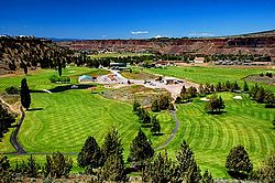
 A golf course at Crooked River Ranch | |
| Coordinates: 44°25′28″N 121°14′18″W / 44.4245638°N 121.2383729°W | |
| Country | United States |
| State | Oregon |
| County | Jefferson |
| Elevation | 2,600 ft (800 m) |
| Population | |
| • Total | 5,000 |
| Time zone | UTC-8 (Pacific) |
| • Summer (DST) | UTC-7 (Pacific) |
| ZIP code | 97760 |
| Website | www.crookedriverranch.com |
Crooked River Ranch is an unincorporated community in southern Jefferson County, Oregon, United States.[1] A small portion of the ranch is also in north Deschutes County.[2] It is located between the Deschutes River and the Crooked River near the south end of Lake Billy Chinook.[3] It is west of U.S. Route 97 between Culver and Terrebonne. Amenities in the community include a golf course, swimming pool, tennis courts, saloon, disc golf course, horse riding arena and general store.[4] The 12,000-acre (49 km2) ranch has a population of approximately 5,000.[2] It is the largest homeowner association in Oregon.[4] Crooked River Ranch has a Terrebonne mailing address, but the postal service also allows mail addressed to Crooked River, Oregon or Crooked River Ranch, Oregon.[5] The ZIP code is 97760.[5]
History
Prior to European Colonialism, this area was populated by groups of people from what is now known as the Confederated Tribes of Warm Springs.[6]
In 1910,[4] Hillsboro politician Harry V. Gates[7] bought the Crooked River Ranch property from local homesteaders and named it "Gates Ranch".[4] The main ranch house was built in 1916 and is currently in use as a senior center.[4] The property was named "Crooked River Ranch" as early as 1934.[7] In 1961 the ranch was sold to the Thomas Bell family, who operated it as the Z-Z Cattle Co. for the next 10 years.[4] In 1972 Crooked River Ranch was sold and developed as a recreational site.[4] In 1980, the ranch's zoning changed from recreational to rural/residential.[4] In 1992, the site was rezoned as a residential subdivision.[4]
Education
Primary and secondary school students in Crooked River Ranch are served by the Culver School District and the Redmond School District.[2]
See also
References
- ^ U.S. Geological Survey Geographic Names Information System: Crooked River Ranch
- ^ a b c "Ranch Info". Crooked River Realty. Archived from the original on 2010-01-24. Retrieved 2009-12-03.
- ^ Oregon Atlas & Gazetteer (7th ed.). Yarmouth, Maine: DeLorme. 2008. p. 43. ISBN 0-89933-347-8.
- ^ a b c d e f g h i "Crooked River Ranch Club and Maintenance Organization". Retrieved 2009-12-03.
- ^ a b "United States Postal Service ZIP Code Lookup". Retrieved 2009-12-03.
- ^ "NativeLand.ca". Native-land.ca - Our home on native land. Retrieved 2020-09-17.
- ^ a b "Fourteenth annual report of the Federal Power Commission, fiscal year ended June 30, 1934, with additional activities to December 1, 1934. Serial Set Vol. No. 9968, Session Vol. No.56; Report: H.Doc. 26". 1935-01-03: 216–217.
{{cite journal}}: Cite journal requires|journal=(help)
External links


