
Bullfrog Basin
Bullfrog | |
|---|---|
 Bullfrog Location within the state of Utah | |
| Coordinates: 37°30′58″N 110°43′43″W / 37.51611°N 110.72861°W | |
| Country | United States |
| State | Utah |
| County | Kane |
| Time zone | UTC-7 (Mountain (MST)) |
| • Summer (DST) | UTC-6 (MDT) |
| ZIP codes | 84533 |
| Area code | 435 |
| GNIS feature ID | 1435217 |
.jpg)
Bullfrog,[1] or Bullfrog Basin Marina,[2] is a small unincorporated community on the shores of Lake Powell's Bullfrog Bay in the Glen Canyon National Recreation Area of Kane County, Utah, United States.[3] Bullfrog is a popular place on Lake Powell for tourists, fishermen, and outdoor enthusiasts due to its marina and local resources. It is the northern terminus for the Charles Hall Ferry, an automobile ferry that connects across Lake Powell to Halls Crossing in San Juan County. Bullfrog was named after a rock formation on the western side of Mt. Ellsworth that can be seen from Utah State Route 276, heading south.
See also
References
External links
Wikimedia Commons has media related to Bullfrog, Utah.
Municipalities and communities of Kane County, Utah, United States | ||
|---|---|---|
| City | 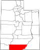 | |
| Towns | ||
| Unincorporated communities | ||
| Ghost towns | ||
This article about a location in Utah is a stub. You can help Wikipedia by expanding it. |