Cavan, South Australia
| Cavan Adelaide, South Australia | |
|---|---|
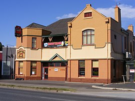
 Cross Keys Hotel, Port Wakefield Road | |
| Population | 40 (2016 census)[1] |
| Established | 1849 |
| Postcode(s) | 5094 |
| LGA(s) | City of Port Adelaide Enfield |
| Federal division(s) | Makin |
Cavan is a suburb north of Adelaide, within the City of Salisbury local government area.
History
The entire area of what is now Mawson Lakes, Pooraka, and Cavan was originally known as Dry Creek.[2] The suburb was either named by Daniel Brady or B. Gillick, both probably Irish immigrants, after Cavan in County Cavan, Republic of Ireland. Brady purchased land and established the 1849 Cross Keys Hotel and Gillick the 1855 Cavan Arms Hotel.[3] However, according to a 2013 article by The Advertiser, the suburb took its name from a local hotel, "The Cavan Arms", which was licensed in 1855 by R.B. Colley who was born in County Cavan in Ireland.[4]
The Northfield railway line, which first opened a station in Cavan in 1914, closed to passenger traffic on 24 July 1987. The Cavan Post Office opened on 2 March 1959 and was later closed in 1974.[5]
References
- ^ Australian Bureau of Statistics (27 June 2017). "Cavan (State Suburb)". 2016 Census QuickStats. Retrieved 15 September 2020.
- ^ Maurovic, Richard (2007). The Meat Game: A History of the Gepps Cross Abattoirs and Livestock Markets. Wakefield Press. ISBN 9781862547261.
- ^ Gunton, Eric (November 1986). Tracing Our Towns, Stories of Same Named Places in South Australia and the United Kingdom. South Australia: Self Published. p. 25. ISBN 0-9592094-2-5.
- ^ "The A-Z history of Adelaide's suburbs". Retrieved 20 September 2017.
- ^ Premier Postal History. "Post Office List". Premier Postal Auctions. Retrieved 26 May 2011.
34°49′41″S 138°35′53″E / 34.828°S 138.598°E
