
Philipp, Mississippi
Philipp, Mississippi | |
|---|---|
 | |
 Philipp, Mississippi  Philipp, Mississippi | |
| Coordinates: 33°45′27″N 90°12′15″W / 33.75750°N 90.20417°W | |
| Country | United States |
| State | Mississippi |
| Counties | Tallahatchie |
| Elevation | 157 ft (48 m) |
| Time zone | UTC-6 (Central (CST)) |
| • Summer (DST) | UTC-5 (CDT) |
| ZIP code | 38950 |
| Area code | 662 |
| GNIS feature ID | 675681[1] |
Philipp is an unincorporated community in southern Tallahatchie County, Mississippi, United States, along Mississippi Highway 8. Philipp is 6 miles (9.7 km) east of Minter City and 14 miles (23 km) west of Holcomb. Although Philipp is an unincorporated community, it has a post office with a ZIP code of 38950.[2]
History
The community was founded by Emanuel L. Philipp who was Governor of Wisconsin when he was the manager of a lumber company from 1894 to 1902 in Mississippi.[3][4]
References
-
 Philipp Volunteer Fire Department
 -
 Philipp Post Office


Municipalities and communities of Tallahatchie County, Mississippi, United States | ||
|---|---|---|
| City | 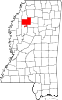 | |
| Towns | ||
| Village | ||
| Unincorporated communities | ||
| Ghost towns | ||
| Footnotes | ‡This populated place also has portions in an adjacent county or counties | |
This Tallahatchie County, Mississippi state location article is a stub. You can help Wikipedia by expanding it. |