
New Taipei Bridge
New Taipei Bridge 新北大橋 | |
|---|---|
 | |
| Coordinates | 25°02′49.4″N 121°29′45.5″E / 25.047056°N 121.495972°E |
| Carries | New Taipei Huanhe Expressaway |
| Crosses | Tamsui River |
| Locale | Sanchong and Wanhua in New Taipei, Taiwan |
| Maintained by | New Taipei City Government |
| Characteristics | |
| Design | Cable-stayed bridge |
| Total length | 1,100 metres (3,609 ft) |
| Width | 43.4 metres (142 ft) |
| Height | 135.75 metres (445 ft) |
| Longest span | 200 metres (656 ft)×2 |
| History | |
| Construction end | 14 August 2010 |
| Location | |
 | |
The New Taipei Bridge (Chinese: 新北大橋; pinyin: Xīnběi Dàqiáo) is a bridge in Sanchong District, New Taipei, Taiwan. It spans over Tamsui River and connects the district to the neighbouring Wanhua District of Taipei City.[1]
Technical specifications
The highest point of the bridge stands at 135.75 meters (around the height of a 40-storey highrise building).[2]
Transportation
The bridge is accessible west from Ximen Station of Taipei Metro.
Gallery
-
 New Taipei Bridge at night.
 -
 View of New Taipei Bridge and sunset skyline of Taipei in 2014.
 -
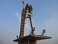 New Taipei Bridge under construction in 2009.
 -
 Signs on New Taipei Bridge.
 -
 New Taipei Bridge bicycle track.


_(4).jpg)
See also
References
- ^ "wwp912: New Taipei Bridge — 新北大橋 - The World Wide Panorama". worldwidepanorama.org. Retrieved 12 December 2014.
- ^ Everington, Keoni (29 March 2018). "Daredevils take extreme photo on top of New Taipei Bridge". Taiwan News. Retrieved 29 March 2018.
Wikimedia Commons has media related to New Taipei Bridge.
This article about a bridge in Taiwan is a stub. You can help Wikipedia by expanding it. |