
Sungailiat
This article needs additional citations for verification. (April 2018) |
Sungailiat | |
|---|---|
Town | |
 Streets of Sungailiat | |
 Sungailiat Location of Sungailiat in Bangka-Belitung | |
| Coordinates: 1°51′20.7″S 106°7′3.4″E / 1.855750°S 106.117611°E | |
| Country | |
| Province | Bangka Belitung Islands |
| Regency | Bangka Regency |
| Area | |
| • Total | 146.63 km2 (56.61 sq mi) |
| Population (2015)[1] | |
| • Total | 94,044 |
| • Density | 640/km2 (1,700/sq mi) |
| Time zone | UTC+7 (Western Indonesia Time) |
| Area code | +62717 |
Sungailiat (Chinese: 烈港), or Lîet-Kóng in Hakka, is a subdistrict/kecamatan of Bangka Regency, Bangka-Belitung province of Indonesia. It is also the capital of the regency.
It is the second-largest settlement on the island, right after the provincial capital of Pangkal Pinang. The town is located on the eastern coast of the island, about 30 kilometers north of Pangkal Pinang and is connected by a paved road.
The subdistrict is further divided into 13 villages (desa or kelurahan).
Economy
As with many settlements in the province, the economy is heavily affected by the mining and processing of tin, abundant in the area. The locals are also engaged in fisheries and agriculture, cultivating rubber trees, pepper, and to a lesser degree palm oil. Small enterprises also exist, processing raw products from the aforementioned industries into light foods.[2]
Tourism is a growing sector, with several Buddhist temples and beaches located within the boundaries of the city attracting visitors from the rest of the country.
Climate
Sungailiat has a tropical rainforest climate (Af) with heavy to very heavy rainfall year-round.
| Climate data for Sungailiat | |||||||||||||
|---|---|---|---|---|---|---|---|---|---|---|---|---|---|
| Month | Jan | Feb | Mar | Apr | May | Jun | Jul | Aug | Sep | Oct | Nov | Dec | Year |
| Mean daily maximum °C (°F) | 29.5 (85.1) |
30.0 (86.0) |
30.6 (87.1) |
31.2 (88.2) |
31.5 (88.7) |
31.2 (88.2) |
31.0 (87.8) |
31.4 (88.5) |
31.4 (88.5) |
31.3 (88.3) |
30.7 (87.3) |
29.8 (85.6) |
30.8 (87.4) |
| Daily mean °C (°F) | 26.5 (79.7) |
26.8 (80.2) |
27.1 (80.8) |
27.5 (81.5) |
27.9 (82.2) |
27.7 (81.9) |
27.6 (81.7) |
27.7 (81.9) |
27.8 (82.0) |
27.8 (82.0) |
27.2 (81.0) |
26.8 (80.2) |
27.4 (81.3) |
| Mean daily minimum °C (°F) | 23.5 (74.3) |
23.6 (74.5) |
23.7 (74.7) |
23.9 (75.0) |
24.3 (75.7) |
24.2 (75.6) |
24.2 (75.6) |
24.1 (75.4) |
24.2 (75.6) |
24.4 (75.9) |
23.8 (74.8) |
23.8 (74.8) |
24.0 (75.2) |
| Average precipitation mm (inches) | 386 (15.2) |
241 (9.5) |
231 (9.1) |
232 (9.1) |
248 (9.8) |
182 (7.2) |
158 (6.2) |
128 (5.0) |
139 (5.5) |
186 (7.3) |
306 (12.0) |
399 (15.7) |
2,836 (111.6) |
| Source: Climate-Data.org[3] | |||||||||||||
Demographics
The majority of the people in Sungailiat are Hakka Chinese and Malay. The majority of Chinese are Bhudists, Catholics and Protestants. The Malay are moslems.
Historical Photographs
-
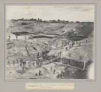 Tin mine
 -
-
 Narrow gauge railway
 -
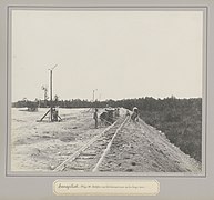 Rail track construction
 -
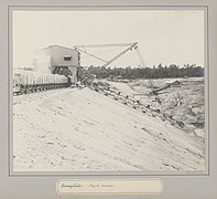
 Excavator
 -

-
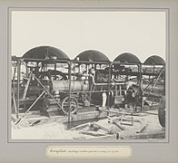 Pump of the suction excavator
 -
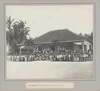 Meeting hall
 -
 Hospital
,_RP-F-F01183-AI.jpg)
,_RP-F-F01183-AB.jpg)
,_RP-F-F01183-AC.jpg)
,_RP-F-F01183-AA.jpg)
,_RP-F-F01183-Y.jpg)
,_RP-F-F01183-AF.jpg)
,_RP-F-F01183-X.jpg)
_te_Soengeiliat_Soengeiliat._Mijn_26._Kongsiehuis_met_het_personeel_en_werkvolk_(titel_op_object),_RP-F-F01183-AE.jpg)
,_RP-F-F01183-AD.jpg)
References
- ^ a b "Bangka Regency - Bureau of Statistics". Badan Pusat Statistik Kabupaten Bangka. Statistics Indonesia. Retrieved 4 August 2017.
- ^ "Statistik Daerah Kecamatan Sungailiat 2016" (PDF). Badan Pusat Statistik Kabupaten Bangka. Bangka Regency Statistics Bureau. Retrieved 4 August 2017.
- ^ "Climate: Sungailiat". Climate-Data.org. Retrieved November 11, 2020.
1°51′22″S 106°07′09″E / 1.85611°S 106.11917°E
This Bangka Belitung location article is a stub. You can help Wikipedia by expanding it. |