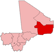
Gao Region
Gao Region | |
|---|---|
 Location within Mali | |
| Coordinates: 17°5′55″N 0°21′5″E / 17.09861°N 0.35139°E | |
| Country | |
| Capital | Gao |
| Area | |
• Total | 170,572 km2 (65,858 sq mi) |
| Population (2009 census)[1] | |
• Total | 544,120 |
| • Density | 3.2/km2 (8.3/sq mi) |
| Time zone | UTC±0 (UTC) |
| HDI (2017) | 0.386[2] low · 5th |

The Gao Region (Bambara: ߜߊߏ ߘߌߣߋߖߊ tr. Gao Dineja) is a region in northeastern Mali. The capital city is Gao.
Geography
The region is bordered to the north by Kidal Region, to the west by Tombouctou Region, and to the east and most of the south by Niger (Tahoua Region and Tillabéri Region), sharing a portion of the southern border with Burkina Faso (Sahel Region).
Demographics
Common ethnicities in the Gao Region include the Songhai, Bozo, Tuareg, Bambara, and Kounta. The towns include Gao, Bourem, and Bamba.
The Gao Region is part of Mali, the northern part that was separated and declared independent by the National Movement for the Liberation of Azawad (MNLA) during the Tuareg rebellion of 2012. After the 1st Battle of Gao, the MNLA lost control to Islamist militias. Several other battles took place during the war, particularly in Gao.
Administrative subdivisions
For administrative purposes, the Gao Region is divided into four cercles:[3]
| Cercle name | Area (km2) | Population Census 1998 |
Population Census 2009 |
|---|---|---|---|
| Ansongo | 23,614 | 82,398 | 132,205 |
| Bourem | 43,000 | 80,667 | 115,958 |
| Gao | 31,250 | 143,300 | 239,853 |
| Ménaka | 73,664 | 35,177 | 56,104 |
History
Gao Region formerly comprised the entire eastern portion of the country, east of Tombouctou Region. In 1991 the northern half of Gao Region became Kidal Region.
See also
References
- ^ Resultats Provisoires RGPH 2009 (Région de Gao) (PDF), République de Mali: Institut National de la Statistique, archived from the original (PDF) on 2011-07-22
- ^ "Sub-national HDI - Area Database - Global Data Lab". hdi.globaldatalab.org. Retrieved 2018-09-13.
- ^ Communes de la Région de Gao (PDF) (in French), Ministère de l'administration territoriale et des collectivités locales, République du Mali, archived from the original (PDF) on 2014-12-16.
External links
- Schéma Régional d’Aménagement et de Développement de la Région de Gao (in French), Assemblée Regionale, Région de Gao, République du Mali, 2008[permanent dead link].

