
Namaste Falls
| Namaste Falls | |
|---|---|
 Namaste Falls | |
 | |
 | |
| Location | Bhedetar, Dhankuta, Nepal |
| Coordinates | 26°52′16″N 87°19′48″E / 26.871°N 87.330°E |
| Type | Plunge |
| Total height | 80 average |
| Number of drops | 1 |
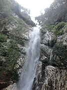
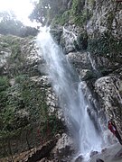
Namaste Falls (Nepali: नमस्ते झरना) is located in Bhedetar village development committee of Dhankuta district. It is an attractive place for domestic tourists. The falls is about 80 meters high. [1]Domestic tourists from Jhapa, Dhankuta, Morang and Sunsari visit this falls in large. To visit this place one should go along with the river from simsuwa mode upward. One can see a rainbow like seven colour formation while standing close to the waterfall. It is in the shape of Namasthe. The place is also frequently visited by researchers for their research.[2]
Geography
It is located 8 km away from Vedatar.[3]
Tourism
There is a high potential for tourism in this area. Along with these falls, Vedatar and Agricultural Research Station on Pakhribas are also located nearby. However, there are no human settlements nearby which create inconvenience for visitors.[4]
Gallery
-
 A full view of Namaste waterfall
 -
 A full view of Namaste waterfall
 -
 A full view of Namaste waterfall
 -
 A full view of Namaste waterfall
 -
 A full view of Namaste waterfall


.jpg)
See also
References
- ^ "Namaste Waterfalls | Namaste Jharna - Khojnu.com". Retrieved 2020-12-08.
- ^ "Namaste Falls". office of distrtrict development committee dhankuta. Archived from the original on 2015-12-24.
- ^ "पूर्वाञ्चलकै मुख्य पर्यटकीय गन्तव्य भेडेटारको नमस्ते झरना Nepalpatra". Retrieved 2020-12-08.
- ^ "पर्यटक लोभ्याउँदै नमस्ते झरना". Thaha Khabar. Retrieved 2020-12-08.