
Mineola, Arkansas
Mineola, Arkansas | |
|---|---|
 Mineola  Mineola | |
| Coordinates: 34°18′48″N 94°01′51″W / 34.31333°N 94.03083°W | |
| Country | |
| State | |
| County | Howard |
| Elevation | 301 m (988 ft) |
| Time zone | UTC-6 (Central (CST)) |
| • Summer (DST) | UTC-5 (CDT) |
| GNIS feature ID | 72690 |
| U.S. Geological Survey Geographic Names Information System: Mineola, Arkansas | |
Mineola (also Minieola) is an unincorporated community in Howard County, Arkansas, United States.[1] On April 24, 2011, an EF1 tornado causing some damage, part of the 2011 Super Outbreak, traveled from Umpire to Mineola parallel to Arkansas State Route 84.[2]
References
- ^ "Feature Detail Report for: Mineola, Arkansas." USGS. U.S. Geological Survey Geographic Names Information System: Mineola, Arkansas Retrieved May 5, 2011.
- ^ http://www.srh.noaa.gov/shv/productview.php?head=NEW&pil=PNS&sid=SHV&version=0 National Weather Service Shreveport (LA) Office Report
Municipalities and communities of Howard County, Arkansas, United States | ||
|---|---|---|
| Cities | 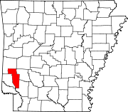 | |
| Town | ||
| CDPs | ||
| Other unincorporated communities | ||
| Ghost towns | ||
| Footnotes | ‡This populated place also has portions in an adjacent county or counties | |
| Authority control databases: Geographic |
|---|
This article about a location in Howard County, Arkansas is a stub. You can help Wikipedia by expanding it. |