Skarð, Iceland
Appearance
Skarð | |
|---|---|
Village | |
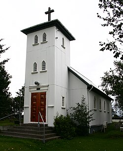
 Skarðskirkja, the Skarð church | |
 Location of the Municipality of Rangárþing ytra | |
| Coordinates: 63°45′N 20°37′W / 63.750°N 20.617°W | |
| Country | |
| Constituency | South Constituency |
| Region | Southern Region |
| Municipality | Rangárþing ytra |
| Time zone | UTC+0 (GMT) |
Skarð is a small village and church parish in southwestern Iceland in the Rangárþing ytra municipality (before 2002: Landsveit), Rangárvallasýsla county, and Southern Region, along road 26 (Landvegur), northwest of Hekla.
The present Skarð church was built in 1931. The parish shares a priest with four other church parishes (Árbæjar, Haga, Kálfholts, Marteinstungu) under the name Fellsmúlaprestakall.[1] This parish and church is called "Skarðskirkja á Landi" to disambiguate from other places named Skarð. The original catholic church was devoted to archangel Michael.[2]
References
- ^ Fellsmúlaprestakall, Suðurland deanery, Church of Iceland.
- ^ Skarðskirkja á Landi (1931), Kirkjukort.net
64°00′18″N 20°05′42″W / 64.0049°N 20.0950°W

