
Biała Rawska
This article needs additional citations for verification. (December 2014) |
Biała Rawska | |
|---|---|
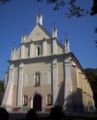
 Church and belfry | |
 Coat of arms | |
 Biała Rawska | |
| Coordinates: 51°48′N 20°29′E / 51.800°N 20.483°E | |
| Country | |
| Voivodeship | Łódź |
| County | Rawa |
| Gmina | Biała Rawska |
| Government | |
| • Mayor | Wacław Adamczyk |
| Area | |
• Total | 9.62 km2 (3.71 sq mi) |
| Population (2016) | |
• Total | 3,212 |
| • Density | 330/km2 (860/sq mi) |
| Time zone | UTC+1 (CET) |
| • Summer (DST) | UTC+2 (CEST) |
| Postal code | 96-230 |
| Car plates | ERW |
| Website | http://www.bialarawska.pl/ |
Biała Rawska [ˈbʲawa ˈrafska] is a town in Rawa County, Łódź Voivodeship, Poland, with 3,212 inhabitants (2016).[1]
History
Biala Rawska is one of the oldest Slavic settlements of historic Mazovia. In the 12th century, it probably was an administrative center and the seat of a castellan, but first written document which confirms the existence of Bela, as it was called, comes from 1246. The gord of Bela was protected by a wooden rampart, as it did not have a defensive wall. The castellany of Bela was in the 14th century transferred to Rawa Mazowiecka.
It is not known when Biala Rawska received town charter, but it happened before 1498. At that time, the town was property of Bishops of Chelm, and was an important administrative center, seat of Biala County of Rawa Voivodeship. Located along busy merchant trails to Mazovian Czersk, Leczyca and Sandomierz, Biala prospered. Good times ended in the 1650s, during the disastrous Swedish invasion of Poland, after which the population of Biala was reduced to only 100 people. The town never recovered from Swedish destruction: in 1777, its population was only 186.
In 1870, following January Uprising, Biala lost its town charter, recovering it in 1925. In 1900, the population was over 2,000, with a significant Jewish element. In 1921, Biala's population was 2328, with 38% Poles and 61% Jews.
During World War II, Biala lost 1,800 people. That includes almost all of the approximately 1200 Jews who lived there in 1939. During the war, the Jews were brualized, robbed, and, beginning fall, 1941, forced to live in a ghetto. Six or seven families shared each room and as a consequence there were epidemics of typhus and other diseases. Around ten people a day died in the ghetto. In August 1942, German and Polish police surrounded the ghetto and forced Jews into trains destined for Treblinka. At Treblinka, all were murdered immediately by gassing. Perhaps a literal handful of Biala Rawska's Jews survived the Holocaust.[2]
Notable residents
- Mariusz Pudzianowski (born 1977), strongman and mixed martial artist, 5-time winner of World's Strongest Man title
Gallery
-
 Palace
 -
 Church of Saint Adalbert
 -
 Church gate
 -
 Belfry


External links
References
- ^ Population. Size and Structure and Vital Statistics in Poland by Territorial Division in 2016, as of December 31 (PDF). Warszawa: Główny Urząd Statystyczny. 2017. p. 116. ISSN 2451-2087.
- ^ Megargee, Geoffrey (2012). Encyclopedia of Camps and Ghettos. Bloomington, Indiana: University of Indiana Press. p. Volume II 198-199. ISBN 978-0-253-35599-7.
51°48′20″N 20°28′40″E / 51.80556°N 20.47778°E
| International | |
|---|---|
| National | |
| Geographic | |