Vysoká pri Morave
Appearance
Vysoká pri Morave | |
|---|---|
Municipality | |
 St. Andrew's Church | |
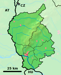
Location of Vysoká pri Morave in the Bratislava Region | |
| Coordinates: 48°19′58″N 16°54′55″E / 48.33278°N 16.91528°E | |
| Country | Slovakia |
| Region | Bratislava |
| District | Malacky |
| Area | |
| • Total | 33.53 km2 (12.95 sq mi) |
| Elevation | 145 m (476 ft) |
| Postal code | 900 66 |
| Area code | 421-2 |
| Car plate | MA |
| Website | www.vysokaprimorave.sk |
Vysoká pri Morave (German: Hochstädten / Hochstetten; Hungarian: Nagymagasfalu) is a village north of Bratislava, the capital city of Slovakia. It is situated in the Malacky District, Bratislava Region on the border to Austria.
External links
![]() Media related to Vysoká pri Morave at Wikimedia Commons
Media related to Vysoká pri Morave at Wikimedia Commons


