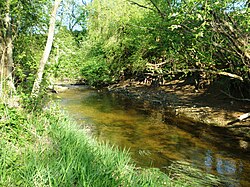
Barupė
| Barupė | |
|---|---|
 Barupė in Pabarupys | |
 | |
| Location | |
| Country | Lithuania |
| Region | Kaunas County |
| Physical characteristics | |
| Source | |
| • location | Nearby Žinėnai, Jonava District Municipality |
| Mouth | Nevėžis in Labūnava |
• coordinates | 55°12′13″N 23°54′20″E / 55.2036°N 23.9056°E |
| Length | 48.2 km (30.0 mi)[1] |
| Basin size | 322.4 km2 (124.5 sq mi)[1] |
| Discharge | |
| • average | 1.55 m³/s[2] |
| Basin features | |
| Progression | Nevėžis→ Neman→ Baltic Sea |
| Tributaries | |
| • left | Savyda, Mėkla, Urka |
| • right | Kulvė, Vabalas, Paparčia |
The Barupė is a river of Jonava District Municipality and Kėdainiai District Municipality, Kaunas County, central Lithuania. It flows for 48.2 kilometres (30.0 mi) and has a basin area of 322 square kilometres (124 sq mi). It is a left tributary of the Nevėžis.
The Barupė river starts next to Žinėnai village, in Jonava District Municipality. It flows northwards, then in Pamelnytėlė turns to the west. It meets the Nevėžis next to Labūnava village.[2]
The upper course in channalised. The lower course has a deep valley. The course has a width of 5–12 metres (16–39 ft) and depth of 0.1–0.4 metres (3.9 in – 1 ft 3.7 in). The flow rate is 0.1–0.2 metres per second (0.33–0.66 ft/s). A large Labūnava Reservoir is dammed on the Barupė river, also smaller ponds are located on the Barupė valley in Kuigaliai and Labūnava.[2]
Sangailiškiai, Kuigaliai, Pėdžiai, Nociūnai, Serbinai, Labūnava villages are located on the shores of the Barupė. A part of river's lower course is protected as the Barupė Landscape Sanctuary.
The hydronym is of uncertain origin. The component upė means 'river' while the root bar- could be of archaic origin, related to Template:Lang-ru 'puddle', Template:Lang-uk 'slough between hills', Illyrian languages: *bar(b)- 'puddle'.[3]
References
- ^ a b B. Gailiušis, J. Jablonskis, M Kovalenkovienė (2001). Lietuvos upės (in Lithuanian). Kaunas: Lietuvos energetikos institutas. p. 507.
{{cite book}}: CS1 maint: multiple names: authors list (link) - ^ a b c Tarybų Lietuvos enciklopedija (in Lithuanian). Vol. 1. Vilnius: Vyriausioji enciklopedijų redakcija. 1985. p. 216.
- ^ Vanagas, Aleksandras (1981). Lietuvių hidronimų etimologinis žodynas (in Lithuanian). Vilnius: Mokslas.
