Wesseling
Appearance
You can help expand this article with text translated from the corresponding article in German. (November 2020) Click [show] for important translation instructions.
|
Wesseling | |
|---|---|
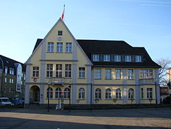
 Old town hall | |
Location of Wesseling within Rhein-Erft-Kreis district  | |
| Coordinates: 50°49′N 6°58′E / 50.817°N 6.967°E | |
| Country | Germany |
| State | North Rhine-Westphalia |
| Admin. region | Cologne |
| District | Rhein-Erft-Kreis |
| Subdivisions | 4 |
| Government | |
| • Mayor | Erwin Esser (SPD) |
| Area | |
| • Total | 23.4 km2 (9.0 sq mi) |
| Highest elevation | 62 m (203 ft) |
| Lowest elevation | 42 m (138 ft) |
| Population (2023-12-31)[1] | |
| • Total | 38,355 |
| • Density | 1,600/km2 (4,200/sq mi) |
| Time zone | UTC+01:00 (CET) |
| • Summer (DST) | UTC+02:00 (CEST) |
| Postal codes | 50389 |
| Dialling codes | 02236, 02232 |
| Vehicle registration | BM |
| Website | www.wesseling.de |

Wesseling is an industrial German city on the Rhine bordering Cologne city on the south. Wesseling originates from the Latin "Wasliacum" which means "Village of Waslica" The story that Wesselig originates from "changing of the rope" (German: Cologne-bred:Wechsel de Ling from when Rhine boats were pulled by horses is something like an urban legend because the name Wesseling is centuries older than the horse-changing station, which was located in Wesseling in the 18th century. In addition to 4 subdivisions, Wesseling has the industrial areas "Rheinbogen" and "Eichholz". Home to several chemical companies including Evonik, and Basell, and a Royal Dutch Shell oil refinery; the city was a bombing target of the Oil Campaign of World War II.
| District | Population (Total: 36.729) |
Area [m²] (Total: 23.373.148) |
|---|---|---|
| Wesseling-Mitte | 12.409 | 7.787.685 |
| Keldenich | 15.000 | 5.535.832 |
| Berzdorf | 4.869 | 4.293.268 |
| Urfeld | 4.057 | 5.756.363 |


