Coalburn
Appearance
| Coalburn | |
|---|---|
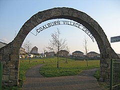
 Coalburn Village Green in 2007 | |
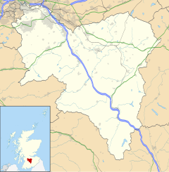
Location within South Lanarkshire | |
| OS grid reference | NS810348 |
| Council area | |
| Lieutenancy area | |
| Country | Scotland |
| Sovereign state | United Kingdom |
| Post town | LANARK |
| Postcode district | ML11 |
| Dialling code | 01555 |
| Police | Scotland |
| Fire | Scottish |
| Ambulance | Scottish |
| UK Parliament | |
| Scottish Parliament | |
Coalburn is a village in South Lanarkshire, Scotland, UK.
History
The opencast mine that opened in the village in the late 1980s became the biggest mine in Europe by the early 1990s.[1]
In 2010 the population was 1267.[2]
Education
Coalburn Primary is a primary school in Coalburn.[3] Their affiliated high school Lesmahagow High School is in the neighbouring town of Lesmahagow.[4]
References
Wikimedia Commons has media related to Coalburn, South Lanarkshire.
- ^ The Jim Hamilton Heritage Society of Coalburn Archived 2016-10-13 at the Wayback Machine coalburnheritage.org.uk
- ^ Current Population (2010) Archived 2011-07-17 at the Wayback Machine
- ^ http://www.coalburn-pri.s-lanark.sch.uk/about-coalburn-primary/
- ^ https://www.southlanarkshire.gov.uk/info/200190/our_secondary_schools/838/lesmahagow_high_school


