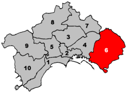
6th municipality of Naples
Sixth Municipality of Naples
Municipalità 6 Sesta Municipalità | |
|---|---|
Borough | |
 Location within Naples | |
| Country | |
| Municipality | |
| Established | 2005 |
| Seat | Corso Sirena, 305 |
| Government | |
| • President | Anna Cozzino |
| • Vice President | Massimo Cilenti |
| Area | |
| • Total | 19.28 km2 (7.44 sq mi) |
| Population (2007) | |
| • Total | 117,641 |
| • Density | 6,100/km2 (16,000/sq mi) |
| Website | M6 on Naples site |
The Sixth Municipality (In Italian: Sesta Municipalità or Municipalità 6) is one of the ten boroughs in which the Italian city of Naples is divided.[1] It is the largest municipality in the city by surface area.
Geography
The municipality represents the easternmost suburb of the city and borders with Portici, San Giorgio a Cremano, San Sebastiano al Vesuvio, Cercola, Volla and Casoria.
Its territory includes the zone of Pietrarsa, in front of San Giorgio, famous for the railway museum.
Administrative division
The Sixth Municipality is divided into 3 quarters:
| Quarter | Population | Area (km²) |
|---|---|---|
| Barra | 38,183
|
7.82
|
| Ponticelli | 54,097
|
9.11
|
| San Giovanni a Teduccio | 25,361
|
2.35
|
| Total | 117,641
|
19.28
|
References
- ^ (in Italian) Statute of Neapolitan Municipalities
External links
- (in Italian) Municipalità 6 page on Naples website
