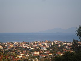
Asprovalta
Asprovalta
Ασπροβάλτα | |
|---|---|
Settlement | |
 | |
| Coordinates: 40°43′N 23°42′E / 40.717°N 23.700°E | |
| Country | Greece |
| Administrative region | Central Macedonia |
| Regional unit | Thessaloniki |
| Municipality | Volvi |
| Municipal unit | Agios Georgios |
| Population (2011)[1] | |
| • Community | 2,838 |
| Time zone | UTC+2 (EET) |
| • Summer (DST) | UTC+3 (EEST) |


Asprovalta (Greek: Ασπροβάλτα, Asproválta) is a town in the regional unit of Thessaloniki in northern Greece. It was the seat of the Agios Georgios municipality. Since the implementation of the Kallikratis Plan in January 2011, Asprovalta belongs to the Municipality of Volvi. Its population numbers 2,838 people.
History
Near the modern town, the ruins of a Roman station of the Via Egnatia are preserved which was called Pennana.[2] According to a manuscript of Simonopetra monastery in Mount Athos, Asprovalta was built in the 16th century. Its first name was Aspra Valta. After the Asia Minor Disaster, 54 families from Erenköy of Troas (near the ancient city of Ophryneion) were installed in Asprovalta.[3]
Historical population
| Census | Population |
|---|---|
| 1991 | 2,366 |
| 2001 | 2,997 |
| 2011 | 2,838 |
References
- ^ "Απογραφή Πληθυσμού - Κατοικιών 2011. ΜΟΝΙΜΟΣ Πληθυσμός" (in Greek). Hellenic Statistical Authority.
- ^ [1] D. C. Samsaris, Pennana, A Roman station (mutatio) of the Via Egnatia (in Greek), Dodona 15 (1986), 1, p. 69-84.
- ^ "Ιστορία". Δημοτικό Σχολείο Ασπροβάλτας. Archived from the original on 24 July 2014. Retrieved 15 July 2014.


