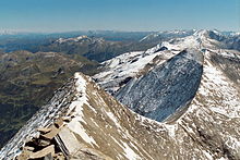
Bratschen

Bratschen are weathering products that occur as a result of frost and aeolian corrasion almost exclusively on the calc-schists of the Upper Slate Mantle (Obere Schieferhülle) in the High Tauern mountains of Austria. The term is German but is used untranslated in English sources.[1] It may be the equivalent of the New Zealand climbers' term 'weet-bix' for a rock that disintegrates easily and so is difficult to climb on.
The calc-schist, that appears blue-gray when freshly broken, weathers to a yellow to brown colour and flakes off on the surface to form bratschen.[2]
These form steep (up to 40°), rocky, almost unvegetated mountainsides with an odd and rough-textured surface, caused by wind erosion. Bratschen are found on the mountains such as the Fuscherkarkopf, the Großer Bärenkopf, the Kitzsteinhorn, the Schwerteck or on the – eponymous – Bratschenköpfen.
References
- ^ For example here: Kendlspitze at www.summitpost.org. Retrieved 12 Dec 2016.
- ^ H. P. Cornelius, E. Clar (1935), Geologische Bundesanstalt — Wien III (ed.), [pdf, geologie.ac.at "Erläuterungen zur geologischen Karte des Großglocknergebietes"], Geologische Karte der Republik Österreich (in German), p. 10, retrieved 2010-05-05
{{citation}}: Check|url=value (help)
Sources
- Karl Krainer (2005), Nationalpark Hohe Tauern GEOLOGIE – Wissenschaftliche Schriften (in German) (2nd ed.), Klagenfurt: Universitätsverlag Carinthia, p. 140, ISBN 3-85378-585-9
