
Hooiberg
12°31′01″N 69°59′42″W / 12.517°N 69.995°W

Hooiberg is a 165 m (541 ft) high volcanic formation on the island of Aruba. It is located almost in the center of the island and can be seen from virtually anywhere on the island.
The Dutch word hooiberg, literally translates into haystack in English, as the landform is said to resemble a stack of hay.[1]
Many have remarked about the panoramic views obtained atop Hooiberg. 662 concrete steps lead to the top of the mountain. On a clear day Venezuela can be seen from the top. The windswept mountaintop is also the site of several radio antennas and cell sites used by Setar, an Aruban telecommunication company.
Gallery
-
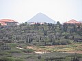 Viewed from California Lighthouse
 -
 Parking lot
 -
 Staircase to the top
 -
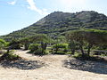
 View from near the top of the hill


References
Wikimedia Commons has media related to Hooiberg.
- ^ Sullivan, Lynne M. (2006). Adventure Guide to Aruba, Bonaire & Curaçao. Hunter Publishing, Inc. p. 81. Retrieved 15 December 2013.
This Aruba location article is a stub. You can help Wikipedia by expanding it. |