
Paradise Street, Oxford

Paradise Street is a street in central Oxford, England.[1] It is in the St Ebbe's area of Oxford, to the southwest of Oxford Castle.
The street runs from Paradise Square to Quaking Bridge, across Castle Mill Stream. It continues to the east into Castle Street.
Historically, both Greyfriars and Blackfriars lived here.[1] On the south side of the street is a late 17th-century house, Greyfriars, conserved in 1985.
Swan Bridge is a Grade II listed bridge over the Castle Mill Stream forming part of Paradise Street. The bridge was Grade II listed in 1972.[2]
The Swan's Nest Brewery, later the Swan Brewery, was established by the early 18th century in Paradise Street. In 1795, it was acquired by William Hall.[3] The brewery became known as Hall's Oxford Brewery, which acquired other local breweries. Hall's Brewery was acquired by Samuel Allsopp & Sons in 1926, after which it ceased brewing in Oxford.[4]
In 1885, Castle Terrace was built by F. J. Codd in the street. This became Simon House, for homeless men.
See also
Gallery
-
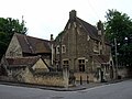 The former St Ebbe's Rectory, designed by G. E. Street in 1852, off Paradise Street
 -
 Another view of the St Ebbe's Rectory
 -
 .Blue plaque for John Stansfield (1854–1939), Rector of St Ebbe's Church 1912–26, on the wall of the former St Ebbe's Rectory
 -
 Detail of the porch on the former school on Paradise Street
 -
 The Jolly Farmer public house on Paradise Street


References
- ^ a b Hibbert, Christopher, ed. (1988). "Paradise Street". The Encyclopaedia of Oxford. Macmillan. p. 313. ISBN 0-333-39917-X.
- ^ "Swan Bridge, Oxford". British Listed Buildings. Retrieved 20 August 2012.
{{cite web}}: External link in|work= - ^ Page, W.H., ed. (1907). "Industries: Malting and Brewing". A History of the County of Oxford. Victoria County History. Vol. Volume 2. Archibald Constable & Co. pp. 225–277.
{{cite book}}:|volume=has extra text (help) - ^ Richmond, Lesley; Turton, Alison (1990). The Brewing industry: a guide to historical records. p. 165. ISBN 978-0-7190-3032-1.
51°45′04″N 1°15′49″W / 51.7511°N 1.2636°W
This Oxfordshire location article is a stub. You can help Wikipedia by expanding it. |