Qońirat
Qo‘ng‘irot
| |
|---|---|
| Coordinates: 43°02′59″N 58°51′15″E / 43.04972°N 58.85417°E | |
| Country | |
| Autonomous Republic | Karakalpakstan |
| District | Qo‘ng‘irot District |
| Elevation | 60 m (200 ft) |
| Population (2018) | |
| • Total | 80,090 |
| Time zone | UTC+5 (UZT) |
| Website | kungrad.com |
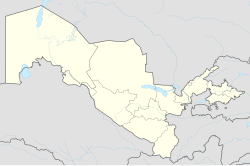
Qo‘ng‘irot also spelled as Kungrad (Uzbek: Qo‘ng‘irot / Қўнғирот; Karakalpak: Qońırat / Қоңырат; Russian: Кунград) and Kungirot, formerly known as Zheleznodorozhny (Russian: Железнодорожный, until 1969), is a town in Karakalpakstan, Uzbekistan, located in the Amu Darya delta on the left bank of the river. Population: 80,090 (2018).[1]
References
- ^ Число постоянных жителей в Республике Каракалпакстан на 1 января 2018 года, Портал открытых данных Республики Узбекистан
External links


