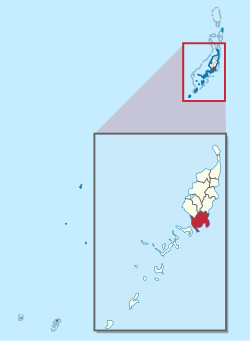
Airai
Airai | |
|---|---|
 Location of Airai in Palau | |
| Country | |
| Capital | Ngetkib |
| Area | |
| • Total | 44 km2 (17 sq mi) |
| Population (2004) | |
| • Total | 2,700 |
| • Density | 61/km2 (160/sq mi) |
| ISO 3166 code | PW-004 |
Airai, located on the southern coast of Babeldaob island, is the second-most populous state of Palau. It contains the country's chief airport, Roman Tmetuchl International Airport, and is connected by the Koror-Babeldaob Bridge to nearby Koror Island.
The state has an area of 44 km² (17 mi²), and a total population of 2700 as of 2004[update], the second largest in the country. Airai is also the name of the biggest town in the state, with a population of 920 people as of 2005[update]. The town of Airai is the largest town in Palau outside of the state of Koror.
Airai is most notable for its Bai (men's meeting house), being the oldest one in existence, dating back 200 years. The turbulent rains of Palau did not treat ancient Palaun architecture kindly. Airai is more inland/mountainous-jungle and therefore more of a bedroom community[clarification needed] than anything else.
External links
7°22′N 134°33′E / 7.367°N 134.550°E

