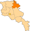
Aknaghbyur
Appearance
40°57′30″N 45°09′23″E / 40.95833°N 45.15639°E
Aknaghbyur
Ակնաղբյուր | |
|---|---|
| Country | Armenia |
| Marz (Province) | Tavush |
| Population (2011[1]) | |
| • Total | 509 |
| Time zone | UTC+4 ( ) |
| • Summer (DST) | UTC+5 ( ) |
Aknaghbyur (Armenian: Ակնաղբյուր; until 1967, Nerkin Agdan and Nerkin Aghdan, Russified as Nizhniy Agdan, from 1967 to 1970, Morut) is a town in the Tavush Province of Armenia. Aknaghbyur was founded in 451 in honor of Vartan Mamikonian and is one of Armenia’s oldest rural communities.[1] In recent years, ArmeniaFund has launched and completed several vital projects on the infrastructure of the town, such as the construction of a gas pipeline and an irrigation system and the renovation of the drinking-water system.[1]
References
- Aknaghbyur at GEOnet Names Server (as Nerkin Agdan)
- Report of the results of the 2001 Armenian Census, Statistical Committee of Armenia
- Kiesling, Brady (June 2000). Rediscovering Armenia: An Archaeological/Touristic Gazetteer and Map Set for the Historical Monuments of Armenia (PDF). Archived (PDF) from the original on 6 November 2021.

