Algeti National Park
| Kolkheti National Park | |
|---|---|
 Landscape around the Algeti reservoir | |
| Location | |
| Nearest city | Manglisi |
| Coordinates | 41°43′N 44°19′E / 41.717°N 44.317°E |
| Area | 6,822 hectares |
| Established | 2007 |
| Visitors | 8,030 (in 2015) |
| Governing body | Agency of Protected Areas |
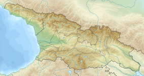
The Algeti National Park (Georgian: ალგეთის ეროვნული პარკი, algetis erovnuli parki) is a protected area in Georgia, in the southeast of the country. It lies in the region of Kvemo Kartli, within the Municipality of Tetritsqaro, some 60 km southwest of the nation’s capital, Tbilisi.
The Algeti National Park stretches along the upper Algeti valley at the woody southern slopes of the eastern Trialeti Range, with the highest point being Mount Kldekari at 2,000 m above sea level. The park was founded under the Soviet government in 1965 as a state reserve to protect the easternmost limits of the Caucasian Spruce and Nordmann Fir. In 2007, it was reorganized into a national park.[1]
References
- ^ Algeti National Park. Agency of Protected Areas of Georgia. Retrieved on January 7, 2010

