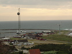
Anholt (Denmark)


Anholt (Danish pronunciation: [ˈanhɔlˀd]) is a Danish island in the Kattegat. The island covers an area of 21,75 km² and has 160 permanent inhabitants. The island can be reached by ferry from Grenå. It is part of Norddjurs municipality in Region Midtjylland. Before the 2007 municipal reform in Denmark it was in Grenå municipality
History
Anholt belonged to the parish of Morup in the Danish province of Halland up until the middle of the 16th century, when a church was built on the island.[1] The island remained Danish when Denmark ceded Halland to Sweden in 1645. An unconfirmed story claims that a glass of beer had been placed over the island on the map during the peace negotiations. The more natural explanation is that the fairly remote island had not been conquered by Swedish forces, and that it was of no importance for Sweden.
From 1808 to 1814, Anholt was occupied by the British who sought to restore the function of the lighthouse. During the Gunboat War, Denmark attempted to retake the island by force. The Battle of Anholt (March 27 1811) proved a decisive British victory and led to many Danish casualties. A monument for the battle is located in Anholt village.
Terrain
The western part of Anholt is a moraine landscape. The small village is situated in the middle of the landscape whereas the harbour (built 1902) is placed at the north western tip of the island. The eastern part of the island is known as the largest desert in Northern Europe, a result of hundreds of years' use of firewood for the important lighthouse on the island's eastern tip. Now, great efforts have been taken to preserve the unique scenery and prevent the devastating effects of erosion. Strictly speaking, the "desert" is not a real desert but a lichen heath.
On the Eastern tip of the island ("Totten"), there is one of the biggest Danish colonies of seals. This part of the island is protected from visitors.
References
- ^ Store Danske Encyklopædi, CD-ROM edition, entry Anholt, 2004.
