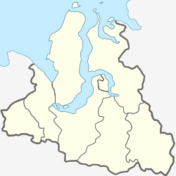
Antipayuta
Appearance
Antipayuta
Антипаюта | |
|---|---|
Settlement | |
| Coordinates: 69°06′N 76°52′E / 69.100°N 76.867°E | |
| Country | |
| Region | Yamalo-Nenets Autonomous Okrug |
| District | Tazovsky District |
| Time zone | UTC+5:00 (YEKT) |
Antipayuta (Russian: Антипаюта) is a rural locality (a settlement) and the administrative center of Antipayuta Rural Settlement of Tasovsky District, Yamalo-Nenets Autonomous Okrug, Russia. The population is 2,685 as of 2017.
Climate
[edit]Antipayuta has a subarctic climate (Köppen climate classification Dfc) with cold, long winters and short, cool summers.[1]
| Climate data for Antipayuta (1991–2020, extremes 1959–present) | |||||||||||||
|---|---|---|---|---|---|---|---|---|---|---|---|---|---|
| Month | Jan | Feb | Mar | Apr | May | Jun | Jul | Aug | Sep | Oct | Nov | Dec | Year |
| Record high °C (°F) | −0.2 (31.6) |
0.9 (33.6) |
1.7 (35.1) |
3.6 (38.5) |
16.3 (61.3) |
30.0 (86.0) |
32.4 (90.3) |
26.4 (79.5) |
20.8 (69.4) |
10.2 (50.4) |
1.5 (34.7) |
0.5 (32.9) |
32.4 (90.3) |
| Mean daily maximum °C (°F) | −21.4 (−6.5) |
−21.0 (−5.8) |
−14.8 (5.4) |
−8.9 (16.0) |
−2.0 (28.4) |
9.7 (49.5) |
17.2 (63.0) |
14.0 (57.2) |
7.1 (44.8) |
−3.0 (26.6) |
−13.7 (7.3) |
−18.7 (−1.7) |
−4.6 (23.7) |
| Daily mean °C (°F) | −25.5 (−13.9) |
−25.1 (−13.2) |
−19.5 (−3.1) |
−13.6 (7.5) |
−4.9 (23.2) |
5.9 (42.6) |
12.7 (54.9) |
10.4 (50.7) |
4.3 (39.7) |
−5.6 (21.9) |
−17.4 (0.7) |
−22.5 (−8.5) |
−8.4 (16.9) |
| Mean daily minimum °C (°F) | −29.7 (−21.5) |
−29.4 (−20.9) |
−24.1 (−11.4) |
−18.5 (−1.3) |
−8.0 (17.6) |
2.8 (37.0) |
8.7 (47.7) |
7.1 (44.8) |
1.8 (35.2) |
−8.5 (16.7) |
−21.4 (−6.5) |
−26.5 (−15.7) |
−12.1 (10.2) |
| Record low °C (°F) | −51.1 (−60.0) |
−51.1 (−60.0) |
−53.0 (−63.4) |
−44.9 (−48.8) |
−30.0 (−22.0) |
−15.5 (4.1) |
−1.1 (30.0) |
−2.7 (27.1) |
−12.2 (10.0) |
−37.1 (−34.8) |
−44.2 (−47.6) |
−50.9 (−59.6) |
−53.0 (−63.4) |
| Average precipitation mm (inches) | 15 (0.6) |
15 (0.6) |
17 (0.7) |
14 (0.6) |
20 (0.8) |
28 (1.1) |
44 (1.7) |
50 (2.0) |
32 (1.3) |
27 (1.1) |
19 (0.7) |
18 (0.7) |
299 (11.8) |
| Source: Pogoda.ru.net[2] | |||||||||||||
Transport
[edit]Antipayuta has an airport.[3] Yamal operates flights with the district center Tazovsky, as well with Nakhodka and Gyda.[4] During the navigable period (mid-July to late September) there is a ferry line between Salekhard and Antipayuta every five days[5]
References
[edit]- ^ Peel, M. C.; Finlayson B. L.; McMahon, T. A. (2007). "Updated world map of the Köppen−Geiger climate classification" (PDF). Hydrol. Earth Syst. Sci. 11 (5): 1633–1644. Bibcode:2007HESS...11.1633P. doi:10.5194/hess-11-1633-2007. ISSN 1027-5606. Archived (PDF) from the original on 3 February 2012. Retrieved 22 February 2013.
- ^ "Погода и Климат – Климат Антипаюта" (in Russian). Weather and Climate (Погода и климат). Retrieved 19 November 2021.
- ^ Аэропорт Антипаюта Archived 2011-04-03 at the Wayback Machine[dead link]
- ^ "Расписание вертолётов 2010". Archived from the original on 2018-01-09. Retrieved 2019-03-27.
- ^ Иртышское речное пароходство: расписание движения на 2011 год


