
Appenzell Alps
| Appenzell Alps | |
|---|---|
 Churfirsten group, with the Schibestoll, Zuestoll, Brisi, Frümsel and Selun (left to right) | |
| Highest point | |
| Peak | Säntis |
| Elevation | 2,502 m (8,209 ft) |
| Naming | |
| Native name | Appenzeller Alpen Error {{native name checker}}: parameter value is malformed (help) |
| Geography | |
Lua error in Module:Location_map at line 526: Unable to find the specified location map definition: "Module:Location map/data/Appenzeller Alpen.png" does not exist.
| |
| Country | Switzerland |
| Cantons | Appenzell Ausserrhoden, Appenzell Innerrhoden, St. Gallen and Zurich |
| Parent range | Western Alps |
| Borders on | Glarus Alps, Rätikon and Schwyz Alps |
| Topo map | Swiss Federal Office of Topography swisstopo |
The Appenzell Alps (German: Appenzeller Alpen) are a mountain range in Switzerland on the northern edge of the Alps. They extend into the cantons of Appenzell Ausserrhoden, Appenzell Innerrhoden and St. Gallen and are bordered by the Glarus Alps to the west and the Rätikon to the south-east.
Sub-ranges
The range is split up into six sub-ranges:
- Alpstein, central group, highest summit: Altmann, 2,435 m
- Alpstein, northern group, highest summit: Säntis, 2,502 m
- Alpstein, southern group, highest summit: Roslen- or Saxerfirst, 2,151 m
- Alviergruppe, highest summit: Gamsberg, 2,385 m
- Churfirsten, highest summit: Hinterrugg, 2,306 m
- Speer - Mattstock, highest summit: Speer, 1,950 m
Geography
Principal summits
The principal summits of the Appenzell Alps are:
- Säntis, 2,502 m
- Girenspitz, 2,448 m
- Altmann, 2,436 m
- Gamsberg, 2,385 m
- Fulfirst, 2,384 m
- Wildhuser Schafberg, 2,373 m
- Wisswand, 2,346 m
- Alvier, 2,343 m
- Hinterrugg, 2,306 m
- Brisi, 2,279 m
- Frümsel, 2,267 m
- Zuestoll, 2,235 m
- Margelchopf, 2,163 m
- Silberplatten, 2,158 m
- Schibestoll, 2,136 m
- Leistchamm, 2,101 m
- Gamser Rugg, 2,076 m
- Kreuzberge, 2,065 m
- Lütispitz, 1,987 m
- Speer, 1,950 m
- Mattstock, 1,936 m
- Schäfler, 1,924 m
- Federispitz, 1,865 m
- Gonzen, 1,830 m
- Hoher Kasten, 1,795 m
- Gulmen, 1,789 m
- Stockberg, 1,781 m
- Kronberg, 1,663 m
- Ebenalp, 1,640 m
- Hochalp, 1,521 m
Other interesting summits
- Kamor, 1,751 m
- Tanzboden, 1,443 m
- Chrüzegg, 1,314 m
- Gäbris, 1,247 m
- Hörnli, 1,133 m
- Köbelisberg, 1,131 m
- Bachtel, 1,115 m
Gallery
-
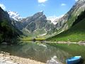
 Säntis from Schwägalp
 -
-
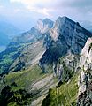 Summit of Churfirsten
 -

-
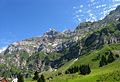
 Near Ebenalp
 -
 Summit of Säntis


